
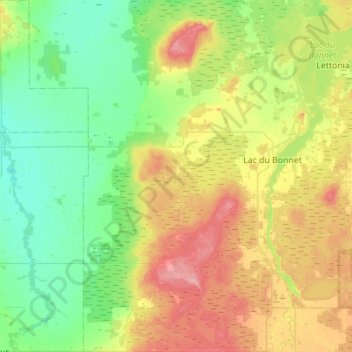
Rural Municipality of Lac du Bonnet topographic map
Interactive map
Click on the map to display elevation.
About this map
Name: Rural Municipality of Lac du Bonnet topographic map, elevation, terrain.
Location: Rural Municipality of Lac du Bonnet, Manitoba, Canada (50.06095 -96.36019 50.41523 -95.80783)
Average elevation: 255 m
Minimum elevation: 225 m
Maximum elevation: 312 m
Other topographic maps
Click on a map to view its topography, its elevation and its terrain.
Winnipeg
Winnipeg lies at the bottom of the Red River Valley, a flood plain with an extremely flat topography. It is on the eastern edge of the Canadian Prairies in Western Canada and is known as the "Gateway to the West". Winnipeg is bordered by tallgrass prairie to the west and south and the aspen parkland to the…
Average elevation: 236 m
Riding Mountain National Park
The climate in the Riding Mountain region is similar to that of other regions of southwestern Manitoba. Under the Köppen classification it has a continental climate. It includes grasslands, upland boreal and eastern deciduous forest ecosystems. The park has hot summers and cold winters, with annual rainfall…
Average elevation: 488 m
Stonewall
When the last ice age retreated, as well as the prairies, escarpments such as Riding Mountain were left behind. In addition to these, smaller elevations were left behind such as Stony Mountain and Stonewall. It is believed that these escarpments were used as look-outs by early hunters approximately 4,000 to…
Average elevation: 251 m
West Hawk Lake
Canada > Manitoba > Unorganized Division No. 1 > West Hawk Lake
Average elevation: 344 m
Hecla/Grindstone Provincial Park
Canada > Manitoba > Unorganized Division No. 18 (East)
Average elevation: 220 m
North Thomas Lake
Canada > Manitoba > Division No. 15 > Rural Municipality of Yellowhead
Average elevation: 596 m
Hecla
Canada > Manitoba > Division No. 18 > Unorganized Division No. 18 (East)
Average elevation: 220 m
West Shoal Lake
Canada > Manitoba > Division No. 18 > Rural Municipality of St. Laurent
Average elevation: 262 m
Elphinstone
Canada > Manitoba > Division No. 15 > Rural Municipality of Yellowhead
Average elevation: 583 m
Bakers Narrows
Canada > Manitoba > Division No. 21 > Unorganized Division No. 21
Average elevation: 297 m
Bowsman
Canada > Manitoba > Division No. 20 > Rural Municipality of Minitonas – Bowsman
Average elevation: 310 m