
Rural Municipality of Piney topographic map
Interactive map
Click on the map to display elevation.
About this map
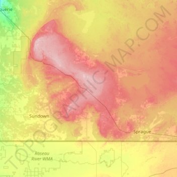
Name: Rural Municipality of Piney topographic map, elevation, terrain.
Average elevation: 333 m
Minimum elevation: 277 m
Maximum elevation: 397 m
Other topographic maps
Click on a map to view its topography, its elevation and its terrain.
Hillside Beach
Canada > Manitoba > Division No. 1 > Rural Municipality of Alexander
Average elevation: 225 m
Whiteshell Provincial Park
Canada > Manitoba > Division No. 1 > Unorganized Division No. 1
Average elevation: 319 m
West Hawk Lake
Canada > Manitoba > Division No. 1 > Unorganized Division No. 1
Average elevation: 349 m
Bird River
Canada > Manitoba > Division No. 1 > Rural Municipality of Alexander
Average elevation: 287 m
East Braintree
Canada > Manitoba > Division No. 1 > Rural Municipality of Reynolds
Average elevation: 317 m
Pinawa
Canada > Manitoba > Division No. 1 > Local Government District of Pinawa
Average elevation: 277 m
Hadashville
Canada > Manitoba > Division No. 1 > Rural Municipality of Reynolds
Average elevation: 300 m