
Patharkandi topographic map
Click on the map to display elevation.
About this map
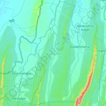
Name: Patharkandi topographic map, elevation, terrain.
Location: Patharkandi, Karimganj, Assam, India (24.23413 92.20113 24.68327 92.41047)
Average elevation: 52 m
Minimum elevation: 4 m
Maximum elevation: 603 m
Other topographic maps
Click on a map to view its topography, its elevation and its terrain.
Sonari
India > Assam > Sonari > Sonari
Sonari is located at 27°04′N 95°02′E / 27.07°N 95.03°E / 27.07; 95.03. It has an average elevation of 97 metres (318 feet). It is a major town on the nearly 500-year-old "Dhodar Ali" built by the Ahom Kings. Dhodar ali was forcefully commissioned by Ahom king Gadadhar Singha using the…
Average elevation: 106 m
Udalguri
India > Assam > Udalguri tehsil
Odalguri is located at 26°44′43″N 92°05′46″E / 26.7452°N 92.0962°E / 26.7452; 92.0962. It has an average elevation of 180 metres (590 ft).
Average elevation: 109 m