Geolocate

Kalain topographic map

Click on the map to display elevation.

About this map

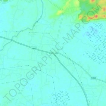
Name: Kalain topographic map, elevation, terrain.

Location: Kalain, Katigora, Cachar, Assam, 788815, India (24.94782 92.55340 24.98782 92.59340)

Average elevation: 21 m

Minimum elevation: 13 m

Maximum elevation: 59 m

Gear up for your next adventure:

🥾Hiking Gaiters - Protect legs and shoes from mud, snow, and debris
👟Trail Running Shoes - Agile footwear for fast-paced topographic exploration
🧤Insulated Winter Gloves - Heavy-duty protection for sub-zero Canadian adventures
🥾Durable Hiking Shoes - Long-lasting shoes for frequent hiking
🧥Softshell Hiking Jacket - The perfect balance of wind protection and breathability

As an Amazon Associate, this site earns from qualifying purchases at no extra cost to you.