
Pyeongtaek-si topographic map
Interactive map
Click on the map to display elevation.
About this map
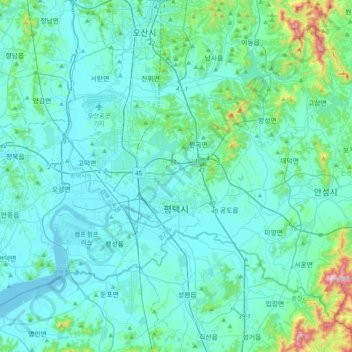
Name: Pyeongtaek-si topographic map, elevation, terrain.
Location: Pyeongtaek-si, Gyeonggi, South Korea (36.89760 126.76073 37.14470 127.15392)
Average elevation: 59 m
Minimum elevation: -3 m
Maximum elevation: 525 m
Other topographic maps
Click on a map to view its topography, its elevation and its terrain.
South Chungcheong
At 845 metres, Mount Gyeryong is the most notable elevation. It is located in a national park which is noted for its unique rock features. Apart from the stone formations there are a number of old temples. These include Gwanchok-sa, a temple which is home to the largest stone Buddha in Korea. In 1978 the Taean…
Average elevation: 89 m
Jeju Island
The climate of the highlands in the middle of the island where Hallasan is located is quite different from those of the rest of the island. The higher the altitude, the lower the average temperature and the colder the climate. The highlands of Jeju Island have the highest annual precipitation in Korea.
Average elevation: 98 m