Geolocate

Guro-gu topographic map

Click on the map to display elevation.

About this map

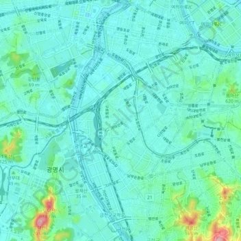
Name: Guro-gu topographic map, elevation, terrain.

Location: Guro-gu, Seoul, South Korea (37.47311 126.81303 37.51778 126.90315)

Average elevation: 28 m

Minimum elevation: -2 m

Maximum elevation: 188 m

Other topographic maps

Click on a map to view its topography, its elevation and its terrain.

GreenField

South Korea > Seoul

Average elevation: 93 m

Cheongnyongsan Mountain

South Korea > Seoul > Gwanak-gu

Average elevation: 78 m

Gye-dong

South Korea > Seoul

Average elevation: 76 m

Gear up for your next adventure:

🎒Hiking Backpack - Lightweight and ergonomic backpacks for day hikes or multi-day treks
🧴Insect Repellent - Protect yourself from bugs during outdoor adventures
🧭Orienteering Kit - Tools for map reading and navigation in the wild
🧢Outdoor Visor - Breathable visor for sunny hikes
🔋Solar Power Bank - Keep your GPS and devices charged during long outdoor trips

As an Amazon Associate, this site earns from qualifying purchases at no extra cost to you.