Geolocate

Cheongdam-dong topographic map

Click on the map to display elevation.

About this map

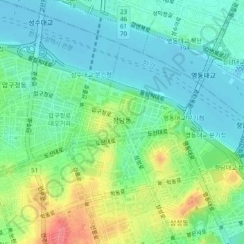
Name: Cheongdam-dong topographic map, elevation, terrain.

Location: Cheongdam-dong, Gangnam-gu, Seoul, South Korea (37.51718 127.03911 37.53456 127.06680)

Average elevation: 28 m

Minimum elevation: 6 m

Maximum elevation: 76 m

Gear up for your next adventure:

💧Hydration Bladder - Hands-free hydration solution for long treks
🧣Evaporative Cooling Towel - Beat the heat during intense summer climbs
🛶Waterproof Dry Bags - Keep electronics and clothes dry during river crossings
🧣Merino Neck Gaiter - Protects against wind, sun, and cold at high altitudes
💡Compact LED Flashlight - Powerful and portable flashlight for outdoor use

As an Amazon Associate, this site earns from qualifying purchases at no extra cost to you.