Geolocate

Seongdong-gu topographic map

Click on the map to display elevation.

About this map

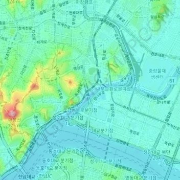
Name: Seongdong-gu topographic map, elevation, terrain.

Location: Seongdong-gu, Seoul, South Korea (37.53012 127.00830 37.57302 127.07376)

Average elevation: 28 m

Minimum elevation: 2 m

Maximum elevation: 166 m

Other topographic maps

Click on a map to view its topography, its elevation and its terrain.

GreenField

South Korea > Seoul

Average elevation: 93 m

Cheongnyongsan Mountain

South Korea > Seoul > Gwanak-gu

Average elevation: 78 m

Gye-dong

South Korea > Seoul

Average elevation: 76 m

Gear up for your next adventure:

🪑Ultralight Camping Stool - Compact seating for rest stops during long hikes
🥽Outdoor Goggles - Protective eyewear for outdoor activities
🧢Outdoor Cap - Protective cap for sun and rain during hikes
Backpacking Tent - Lightweight tent for long-distance hiking trips
🦟Insect Repellent - Keep mosquitoes and black flies away in wooded areas

As an Amazon Associate, this site earns from qualifying purchases at no extra cost to you.