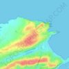
Comillas topographic map
Click on the map to display elevation.
About this map

Name: Comillas topographic map, elevation, terrain.
Location: Comillas, Cantabria, 39528, Spain (43.33957 -4.32305 43.39414 -4.25413)
Average elevation: 84 m
Minimum elevation: -4 m
Maximum elevation: 333 m
Other topographic maps
Click on a map to view its topography, its elevation and its terrain.


Salarzón
Spain > Cantabria > Cillorigo de Liébana
Salarzón is a locality of Cillorigo de Liébana municipality, in the Liébana region of Cantabria, Spain. It is located at 666 meters altitude and it is 6,8 kilometres far from Tama, the municipal capital. It has 33 inhabitants (INE, 2008). This neighborhood belongs to "Bedoya's Council", formed by several…
Average elevation: 746 m







African Elephant, Water Buffalo and Southern Lechwe
Spain > Cantabria > Penagos > Cabárceno
Average elevation: 191 m