Geolocate

Yera topographic map

Click on the map to display elevation.

About this map

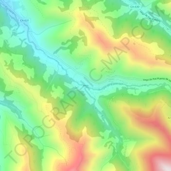
Name: Yera topographic map, elevation, terrain.

Location: Yera, Vega de Pas, Cantabria, 39685, Spain (43.11541 -3.77592 43.15541 -3.73592)

Average elevation: 677 m

Minimum elevation: 352 m

Maximum elevation: 1,189 m

Gear up for your next adventure:

🥾Waterproof Hiking Shoes - Durable shoes for wet and rugged trails
🧥Thermal Layer - Insulating layer for cold outdoor conditions
🧴First Aid Kit - Essential first aid supplies for outdoor emergencies
🛰️Satellite Messenger - Emergency communication for areas with no cell service
🔭Compact Binoculars - Lightweight optics for scouting trails and wildlife

As an Amazon Associate, this site earns from qualifying purchases at no extra cost to you.