Geolocate

Incedo topographic map

Click on the map to display elevation.

About this map

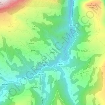
Name: Incedo topographic map, elevation, terrain.

Location: Incedo, Soba, Cantabria, 39808, Spain (43.19418 -3.49897 43.23418 -3.45897)

Average elevation: 395 m

Minimum elevation: 113 m

Maximum elevation: 992 m

Gear up for your next adventure:

🎒Fully Waterproof Backpack - Total protection for photography gear and electronics
🥾Trail Hiking Socks - Comfortable socks to prevent blisters and fatigue
🛶Waterproof Dry Bags - Keep electronics and clothes dry during river crossings
🦌Outdoor Trail Camera - Monitor wildlife activity near your favorite spots
🥾Trail Hiking Boots - Supportive boots for rough trails

As an Amazon Associate, this site earns from qualifying purchases at no extra cost to you.