
La Palma topographic map
Click on the map to display elevation.
La Palma
In a programme transmitted by the British Broadcasting Corporation BBC Horizon broadcast on 12 October 2000, two geologists (Day and McGuire) cited La Grieta as proof that half of the Cumbre Vieja had moved towards the Atlantic Ocean (Day et al.; 1999, and Ward and Day, 2001). They postulate that this process was driven by the pressure caused by the rising magma heating water trapped within the structure of the island. They hypothesised that during a future eruption, the western flank of the Cumbre Vieja, with a mass of approximately 1.5 x10¹⁵ kg, could slide into the ocean. This could then potentially generate a giant wave, known as a "megatsunami" around 650–900 m (2,130–2,950 ft) high in the region of the islands. The wave would radiate out across the Atlantic and inundate much of the eastern seaboard of North America about 7 hours later, many of the islands in the Caribbean and northern coasts of South America between six and eight hours later. They estimate that the tsunami will have waves possibly 50 m (164 ft) or higher causing massive devastation along the coastlines. Modelling suggests that the tsunami could inundate up to 25 km (16 mi) inland – depending upon topography. The basis for Ward and Day (2001) modelling the collapse of a much larger portion of the western flank than what the currently visible surface crack indicates as being potentially unstable, was based on geological mapping by Day et al.; (1999). In this paper they argue that a large part of the western flank has been constructed in the scar of a previous collapse and therefore sits upon unstable debris.
About this map
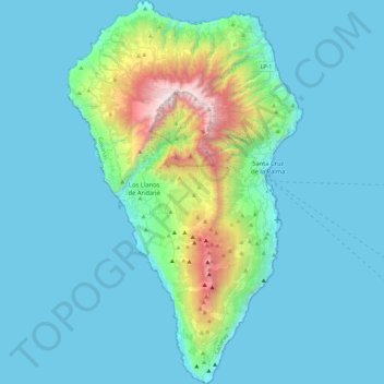
Name: La Palma topographic map, elevation, terrain.
Location: La Palma, Santa Cruz de Tenerife, Canary Islands, Spain (28.45269 -18.00725 28.85789 -17.72422)
Average elevation: 295 m
Minimum elevation: 0 m
Maximum elevation: 2,410 m
Other topographic maps
Click on a map to view its topography, its elevation and its terrain.
Arrutiegia
Spain > Autonomous Community of the Basque Country > Urola-Kosta > Aia
Average elevation: 223 m
Las Vagas
Spain > Aragon > Cuencas Mineras > Martín del Río > La Rambla de Martín
Average elevation: 1,120 m
Urbanització Cala Llonga
Spain > Balearic Islands > Ibiza > Santa Eulària des Riu
Average elevation: 39 m
El Port de la Selva
Spain > Catalonia > Upper Empordà > el Port de la Selva > El Port de la Selva
Average elevation: 76 m
Donostia / San Sebastián
Spain > Autonomous Community of the Basque Country > Donostialdea > Donostia / San Sebastián
Average elevation: 134 m
Presa de Majarobledo
Spain > Extremadura > Las Hurdes > Casares de las Hurdes
Average elevation: 1,080 m
Murcia
Spain > Region of Murcia > Region of Murcia > Murcia
Murcia is located near the center of a low-lying fertile plain known as the huerta (orchard or vineyard) of Murcia. The Segura River and its right-hand tributary, the Guadalentín, run through the area. The city has an elevation of 43 metres (141 ft) above sea level and its municipality covers approximately…
Average elevation: 169 m
Madrid
Spain > Community of Madrid > Área metropolitana de Madrid y Corredor del Henares > Madrid
Average elevation: 650 m