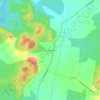
Villa Clara topographic map
Click on the map to display elevation.
Villa Clara
Around Santa Clara, the land rises into the Alturas de Santa Clara. The highest point in the Santa Clara region is in the Alturas, at 464 m (1,522 ft) above sea level, while the south, dominated by the Escambray Mountains, reach elevations of over 900 m (3,000 ft). Villa Clara also has numerous lakes, which are used for both water sports and fishing. The largest Cuban river to drain into the Atlantic, Río Sagua la Grande, is also in Villa Clara province.
About this map

Name: Villa Clara topographic map, elevation, terrain.
Location: Villa Clara, Cuba (21.95131 -80.75656 23.43761 -78.82182)
Average elevation: 52 m
Minimum elevation: -2 m
Maximum elevation: 1,068 m
Other topographic maps
Click on a map to view its topography, its elevation and its terrain.

Havana
Between 1514 and 1519, the Spanish established the first settlements on the northern coast of Cuba near present-day Havana. One of them was called La Chorrera, on the current site of the Tower of La Chorrera, next to the mouth of the Almendares River. This settlement was in a better location than the first on…
Average elevation: 30 m
Havana
Cuba > Havana > La Habana Vieja
There are low hills on which the city lies rise gently from the waters of the straits. A noteworthy elevation is the 200-foot-high (60-meter) limestone ridge that slopes up from the east and culminates in the heights of La Cabaña and El Morro, the sites of Spanish fortifications overlooking the eastern bay.…
Average elevation: 30 m
Havana
There are low hills on which the city lies rise gently from the waters of the straits. A noteworthy elevation is the 200-foot-high (60-meter) limestone ridge that slopes up from the east and culminates in the heights of La Cabaña and El Morro, the sites of Spanish fortifications overlooking the eastern bay.…
Average elevation: 30 m














Havana
There are low hills on which the city lies rise gently from the waters of the straits. A noteworthy elevation is the 200-foot-high (60-meter) limestone ridge that slopes up from the east and culminates in the heights of La Cabaña and El Morro, the sites of Spanish fortifications overlooking the eastern bay.…
Average elevation: 30 m