Geolocate

Soroa topographic map

Click on the map to display elevation.

About this map

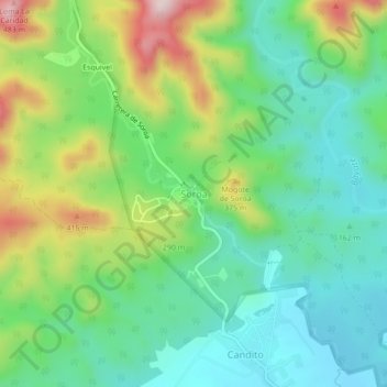
Name: Soroa topographic map, elevation, terrain.

Location: Soroa, Candelaria, Artemisa, 22700, Cuba (22.77389 -83.02783 22.81389 -82.98783)

Average elevation: 205 m

Minimum elevation: 71 m

Maximum elevation: 481 m

Gear up for your next adventure:

🎒Backpack Rain Cover - External shield to keep your entire pack dry
🔥Camping Stove - Portable stoves to cook outdoors with ease
🧊Portable Cooler - Keep food and drinks cold during outdoor adventures
🛶Waterproof Dry Bags - Keep electronics and clothes dry during river crossings
🥾Waterproof Trail Shoes - Shoes designed to handle wet terrain

As an Amazon Associate, this site earns from qualifying purchases at no extra cost to you.