Geolocate

Tapaste topographic map

Click on the map to display elevation.

About this map

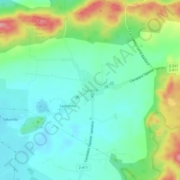
Name: Tapaste topographic map, elevation, terrain.

Location: Tapaste, San José de las Lajas, Mayabeque, 10500, Cuba (23.00394 -82.15648 23.04394 -82.11648)

Average elevation: 155 m

Minimum elevation: 112 m

Maximum elevation: 256 m

Gear up for your next adventure:

🎒Hiking Daypack - Lightweight and durable backpacks for day trips and excursions
🩹Compact First Aid Kit - Pre-packed essentials for common trail injuries
🏕️Camping Hammock - Integrated protection for sleeping between trees
🛶Canoe Life Vest - Safety vest for water sports
🧢Sun Protection Cap - Breathable cap to protect from sun exposure

As an Amazon Associate, this site earns from qualifying purchases at no extra cost to you.