Geolocate

Xavier topographic map

Click on the map to display elevation.

About this map

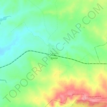
Name: Xavier topographic map, elevation, terrain.

Location: Xavier, Contramaestre, Santiago de Cuba, Cuba (20.29102 -76.13565 20.33102 -76.09565)

Average elevation: 151 m

Minimum elevation: 109 m

Maximum elevation: 217 m

Gear up for your next adventure:

🧥Packable Rain Jacket - Breathable waterproof layer for unpredictable weather
🗺️Topographic Maps - Detailed maps to explore trails, mountains, and wilderness areas
Lightweight Backpacking Tent - Compact tent for efficient hiking trips
🥾Trekking Boots - Durable boots for long-distance trekking
🔋Emergency Crank Radio - Weather alerts and power without needing batteries

As an Amazon Associate, this site earns from qualifying purchases at no extra cost to you.