
Kolkata topographic map
Interactive map
Click on the map to display elevation.
About this map
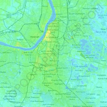
Name: Kolkata topographic map, elevation, terrain.
Location: Kolkata, West Bengal, India (22.45032 88.23700 22.63254 88.45895)
Average elevation: 5 m
Minimum elevation: -3 m
Maximum elevation: 23 m
Spread roughly north–south along the east bank of the Hooghly River, Kolkata sits within the lower Ganges Delta of eastern India approximately 75 km (47 mi) west of the international border with Bangladesh; the city's elevation is 1.5–9 m (5–30 ft). Much of the city was originally a wetland that was reclaimed over the decades to accommodate a burgeoning population. The remaining undeveloped areas, known as the East Kolkata Wetlands, were designated a "wetland of international importance" by the Ramsar Convention (1975). As with most of the Indo-Gangetic Plain, the soil and water are predominantly alluvial in origin. Kolkata is located over the "Bengal basin", a pericratonic tertiary basin. Bengal basin comprises three structural units: shelf or platform in the west; central hinge or shelf/slope break; and deep basinal part in the east and southeast. Kolkata is located atop the western part of the hinge zone which is about 25 km (16 mi) wide at a depth of about 45,000 m (148,000 ft) below the surface. The shelf and hinge zones have many faults, among them some are active. Total thickness of sediment below Kolkata is nearly 7,500 m (24,600 ft) above the crystalline basement; of these the top 350–450 m (1,150–1,480 ft) is Quaternary, followed by 4,500–5,500 m (14,760–18,040 ft) of Tertiary sediments, 500–700 m (1,640–2,300 ft) trap wash of Cretaceous trap and 600–800 m (1,970–2,620 ft) Permian-Carboniferous Gondwana rocks. The quaternary sediments consist of clay, silt and several grades of sand and gravel. These sediments are sandwiched between two clay beds: the lower one at a depth of 250–650 m (820–2,130 ft); the upper one 10–40 m (30–130 ft) in thickness. According to the Bureau of Indian Standards, on a scale ranging from I to V in order of increasing susceptibility to earthquakes, the city lies inside seismic zone III.
Other topographic maps
Click on a map to view its topography, its elevation and its terrain.
Ghuni
Ghuni, North 24 Parganas District, West Bengal, 700161, India
Average elevation: 3 m
Bardhaman
India > West Bengal > Burdwan - I
Bardhaman, Burdwan - I, Purba Bardhaman District, West Bengal, India
Average elevation: 31 m
Mandirbazar
Mandirbazar, South 24 Parganas District, West Bengal, 743336, India
Average elevation: 4 m
Durgapur
India > West Bengal > Faridpur Durgapur
Durgapur, Faridpur Durgapur, Paschim Bardhaman District, West Bengal, 713200, India
Average elevation: 76 m
Tufanganj - II
Tufanganj - II, Cooch Behar District, West Bengal, 736131, India
Average elevation: 40 m
Kharibari
India > West Bengal > Kharibari
Kharibari, Darjeeling District, West Bengal, 734427, India
Average elevation: 88 m
Sitai
Sitai, Cooch Behar District, West Bengal, 736167, India
Average elevation: 39 m
Odlabari
India > West Bengal > Mal
Odlabari, Mal, Jalpaiguri District, West Bengal, 735222, India
Average elevation: 168 m
Maheshtala
India > West Bengal > Thakurpukur Maheshtala
Maheshtala, Thakurpukur Maheshtala, South 24 Parganas District, West Bengal, 700141, India
Average elevation: 5 m
Purulia
India > West Bengal > Purulia - II
Purulia, Purulia - II, Puruliya, West Bengal, 723101, India
Average elevation: 241 m
Matigara block
Matigara block, Darjeeling district, West Bengal, India
Average elevation: 139 m
Tamluk
India > West Bengal > Tamluk
Tamluk, Purba Medinipur, West Bengal, 721600, India
Average elevation: 3 m
Chanchal
India > West Bengal > Chanchal - I
Chanchal, Chanchal - I, Maldah, West Bengal, 732123, India
Average elevation: 28 m
Rajpur Sonarpur
India > West Bengal > Sonarpur > Rajpur Sonarpur
Rajpur Sonarpur, Sonarpur, South 24 Parganas, West Bengal, 700150, India
Average elevation: 4 m
Kalyani
India > West Bengal > Chakdah > Kalyani
Kalyani, Chakdah, Nadia, West Bengal, 741235, India
Average elevation: 9 m
Bidhannagar
India > West Bengal > Bhangar - II
Bidhannagar, Bhangar - II, South 24 Parganas, West Bengal, 700064, India
Average elevation: 5 m
Ilam Bazar
India > West Bengal > Illambazar > Ilam Bazar
Ilam Bazar, Illambazar, Birbhum, West Bengal, 731214, India
Average elevation: 58 m
Baduria
India > West Bengal > Baduria > Baduria
Baduria, North 24 Parganas, West Bengal, 743401, India
Average elevation: 5 m
Singur
India > West Bengal > Singur > Singur
Singur, Hugli, West Bengal, 712409, India
Average elevation: 9 m
উত্তর দেয়াড়া
India > West Bengal > Baduria > উত্তর দেয়াড়া
উত্তর দেয়াড়া, Baduria, North 24 Parganas, West Bengal, 743401, India
Average elevation: 5 m
Dhakuria Lake
India > West Bengal > Kolkata
Dhakuria Lake, Dhakuria, Kolkata, West Bengal, India
Average elevation: 9 m
Naihati
India > West Bengal > Barrackpur - I > Naihati
Naihati, Barrackpur - I, North 24 Parganas, West Bengal, 743165, India
Average elevation: 9 m
Maldah (Old)
India > West Bengal > Maldah (Old)
Maldah (Old), Maldah, West Bengal, India
Average elevation: 27 m
Sittong, West Bengal
India > West Bengal > Kurseong Subdivision
Sittong, West Bengal, Kurseong Subdivision, Darjeeling district, West Bengal, India
Average elevation: 466 m
Siuri
India > West Bengal > Suri - I > Siuri
Siuri, Suri - I, Birbhum, West Bengal, 731101, India
Average elevation: 66 m
Mahanagar
India > West Bengal > Gazole > Mahanagar
Mahanagar, Gazole, Maldah, West Bengal, India
Average elevation: 31 m
Asansol
India > West Bengal > Asansol
Asansol, Asansol Kulti Township, Paschim Bardhaman, West Bengal, India
Average elevation: 114 m
Subarnarekha River
Subarnarekha River, West Bengal, 831, India
Average elevation: 155 m
Serampore
India > West Bengal > Serampore
Serampore, Serampur Uttarpara, Hugli, West Bengal, 712201, India
Average elevation: 7 m
Hugli-Chuchura
India > West Bengal > Chinsurah - Magra
Hugli-Chuchura, Chinsurah - Magra, Hugli, West Bengal, 712101, India
Average elevation: 9 m
Cooch Behar - II
Cooch Behar - II, Kochbihar, West Bengal, India
Average elevation: 47 m
Kaliachak
India > West Bengal > Kaliachak
Kaliachak, Kaliachak - I, Maldah, West Bengal, 732201, India
Average elevation: 26 m
Bardhaman
India > West Bengal > Bardhaman
Bardhaman, Burdwan - I, Purba Bardhaman, West Bengal, 713103, India
Average elevation: 30 m
Howrah
India > West Bengal > Howrah
Howrah, Haora, Howrah, West Bengal, 711101, India
Average elevation: 5 m
Kolkata
India > West Bengal > Thakurpukur Maheshtala > Howrah
Kolkata, Howrah, Thakurpukur Maheshtala, Howrah, West Bengal, 711101, India
Average elevation: 5 m
Chinsurah - Magra
Chinsurah - Magra, Hugli, West Bengal, India
Average elevation: 9 m