
Siuri topographic map
Click on the map to display elevation.
Siuri
Suri is located at 23°54′36″N 87°31′37″E / 23.910°N 87.527°E / 23.910; 87.527. Suri is 220 km from State capital Kolkata (Calcutta), 90 km from Durgapur, 34 km from Bolpur–Santiniketan, 55 km from Andal and 19 km from Sainthia on the Andal–Sainthia branch line of Eastern Railway. It is on Panagarh–Morgram Highway.(known as N.H 60). It has an average elevation of 71 metres (233 feet). It is situated on the extended part of Chota Nagpur Plateau. Tilpara barrage on Mayurakshi River is located 3 km north-west of Suri.
About this map
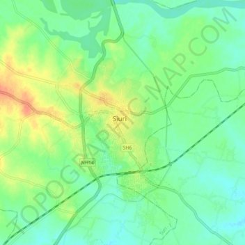
Name: Siuri topographic map, elevation, terrain.
Location: Siuri, Suri - I, Birbhum, West Bengal, 731101, India (23.74658 87.36888 24.06658 87.68888)
Average elevation: 66 m
Minimum elevation: 32 m
Maximum elevation: 132 m