Geolocate

Tamluk topographic map

Click on the map to display elevation.

About this map

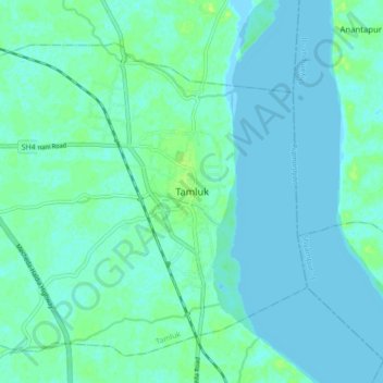
Name: Tamluk topographic map, elevation, terrain.

Location: Tamluk, Purba Medinipur, West Bengal, 721600, India (22.24970 87.88559 22.32970 87.96559)

Average elevation: 3 m

Minimum elevation: -1 m

Maximum elevation: 12 m

Gear up for your next adventure:

🧢Sun Protection Cap - Breathable cap to protect from sun exposure
🛶Kayak Accessories - Essential gear for safe and fun kayaking adventures
🥾Trail Running Shoes - Lightweight and durable shoes for trail running
🧦Crew Hiking Socks - Comfortable socks for long-distance hikes
🦯Trekking Poles - Reduced impact on joints for steep topographic climbs

As an Amazon Associate, this site earns from qualifying purchases at no extra cost to you.