
Valladolid topographic map
Click on the map to display elevation.
Valladolid
Valladolid is located at roughly 735 metres above sea level, at the centre of the Meseta Norte, the plateau drained by the Duero river basin covering a major part of the Northwest of the Iberian Peninsula. The primitive urban core was built ex novo in the 11th century on a small elevation near the confluence of the Esgueva with the Pisuerga, on the left-bank of the latter river. The city of Valladolid currently lies on both banks of the Pisuerga, a major right-bank tributary of the Douro.
About this map
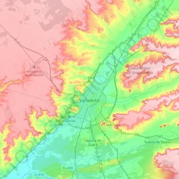
Name: Valladolid topographic map, elevation, terrain.
Location: Valladolid, Castile and León, Spain (41.52313 -4.92818 41.81551 -4.63081)
Average elevation: 768 m
Minimum elevation: 672 m
Maximum elevation: 868 m
Other topographic maps
Click on a map to view its topography, its elevation and its terrain.
Valtuille de Abajo
Spain > Castile and León > El Bierzo > Villafranca del Bierzo
Average elevation: 525 m
Ávila
Ávila is the capital and most populated municipality of the Province of Ávila, located in the autonomous community of Castile and León in Spain. Located in the centre of the Iberian Peninsula, to the north of the Sistema Central, it lies on the right bank of the Adaja and, at an elevation of over 1,130…
Average elevation: 1,167 m
Sierra de Guadarrama
The range runs southwest–northeast, extending from the province of Ávila in the southwest, through the Community of Madrid, to the province of Segovia in the northeast. The range measures approximately 80 kilometres (50 mi) in length. Its highest peak is Peñalara, 2,428 metres (7,966 ft) in elevation.
Average elevation: 1,153 m
Yacimiento arqueológico La Edrada
Spain > Castile and León > El Bierzo > Cacabelos
Average elevation: 493 m