Geolocate

Valdez topographic map

Click on the map to display elevation.

About this map

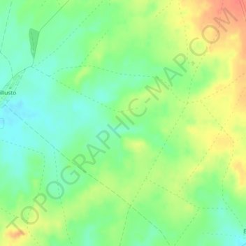
Name: Valdez topographic map, elevation, terrain.

Location: Valdez, Villadiego, Burgos, Castile and León, Spain (42.55077 -4.05211 42.57077 -4.03211)

Average elevation: 882 m

Minimum elevation: 861 m

Maximum elevation: 908 m

Gear up for your next adventure:

🥾Waterproof Trail Shoes - Shoes designed to handle wet terrain
🛶Canoe Life Vest - Safety vest for water sports
🔥Camping Stove - Portable stoves to cook outdoors with ease
👖Convertible Hiking Pants - Zip-off legs to adapt to changing weather conditions
🧳Compression Sacks - Maximize space in your backpack by shrinking gear

As an Amazon Associate, this site earns from qualifying purchases at no extra cost to you.