
Make a donation
Bruce County topographic map
Interactive map
Click on the map to display elevation.


About this map
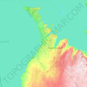
Name: Bruce County topographic map, elevation, terrain.
Location: Bruce County, Ontario, Canada (43.90797 -81.79400 45.36196 -80.90367)
Average elevation: 232 m
Minimum elevation: 171 m
Maximum elevation: 540 m
Ontario trails, hiking, mountain biking, running and outdoor activities
Other topographic maps
Click on a map to view its topography, its elevation and its terrain.
Toronto
Despite its deep ravines, Toronto is not remarkably hilly, but its elevation does increase steadily away from the lake. Elevation differences range from 76.5 metres (251 ft) above sea level at the Lake Ontario shore to 209 m (686 ft) ASL near the York University grounds in the city's north end at the…
Average elevation: 113 m
London
Canada > Ontario > London > London
London has a humid continental climate (Köppen Dfb), though due to its downwind location relative to Lake Huron and elevation changes across the city, it is virtually on the Dfa/Dfb (hot summer) boundary favouring the former climate zone to the southwest of the confluence of the South and North Thames Rivers,…
Average elevation: 268 m
Guelph
This region of Ontario has cold winters and warm, humid summers, falling into the Köppen climate classification Dfb zone, with moderately high rainfall and snowfall. It is generally a couple of degrees cooler than lower elevation regions on the Great Lakes shorelines, especially so in winter, the exception…
Average elevation: 344 m
Peterborough
Canada > Ontario > Peterborough
Peterborough's topography is largely defined by land formations created by the receding Wisconsian glaciers 10,000–15,000 years ago. The South End and Downtown portions of the City sit on what was the bottom of the glacial Lake Peterborough—part of a glacial spillway created when glacial meltwaters from…
Average elevation: 235 m
Seeleys Bay
Canada > Ontario > Leeds and Grenville Counties > Leeds and the Thousand Islands > Seeley's Bay
Average elevation: 105 m
Moose Factory Island
Canada > Ontario > Cochrane District > Unorganized North Cochrane
Average elevation: 4 m
Glen Nevis
Canada > Ontario > Stormont, Dundas and Glengarry Counties > South Glengarry
Average elevation: 70 m
Beckwith Island
Canada > Ontario > Simcoe County
The island's highest elevation is 226 meters (741 feet) above sea level. Like its populated neighbour Christian Island to the west, and Hope Island to the northwest, the uninhabited island is part of an Ojibwa reserve. On the mainland, Cedar Point lies directly south of the island and Thunder Beach is located…
Average elevation: 185 m
Moose Factory Island
Canada > Ontario > Cochrane District > Unorganized North Cochrane
Average elevation: 4 m
Nestor Falls
Canada > Ontario > Kenora District > Sioux Narrows-Nestor Falls Township
Average elevation: 337 m
Tower Mountain
Canada > Ontario > Thunder Bay District > Unorganized Thunder Bay District
Average elevation: 575 m
Dundas
Canada > Ontario > Hamilton > Dundas
Dundas /ˈdʌnˌdæs/ is a community and former town in Hamilton, Ontario, Canada. It is nicknamed the Valley Town because of its topographical location at the bottom of the Niagara Escarpment on the western edge of Lake Ontario. The population has been stable for decades at about twenty thousand, largely…
Average elevation: 171 m
Cardinal (Lac) Lake
Canada > Ontario > Kenora District > Unorganized Kenora District
Average elevation: 392 m
Lake Bernard
Canada > Ontario > Parry Sound District > Strong Township > Sundridge
Average elevation: 347 m