Geolocate

Kingston topographic map

Click on the map to display elevation.

About this map

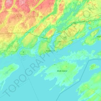
Name: Kingston topographic map, elevation, terrain.

Location: Kingston, Eastern Ontario, Ontario, K7L 2Z3, Canada (44.07069 -76.64132 44.39069 -76.32132)

Average elevation: 94 m

Minimum elevation: 71 m

Maximum elevation: 179 m

Kingston trails, hiking, mountain biking, running and outdoor activities

Other topographic maps

Click on a map to view its topography, its elevation and its terrain.

Mill Pond

Canada > Ontario > Kingston

Average elevation: 94 m

Loughborough Lake

Canada > Ontario > Kingston > South Frontenac

Average elevation: 132 m

Gear up for your next adventure:

🦟Insect Repellent - Keep mosquitoes and black flies away in wooded areas
🕶️Polarized Sunglasses - Reduces glare from snow and water at high elevations
🎒Hiking Daypack - Lightweight and durable backpacks for day trips and excursions
🦌Outdoor Trail Camera - Monitor wildlife activity near your favorite spots
🥾All-Terrain Hiking Boots - Versatile boots for varied hiking conditions

As an Amazon Associate, this site earns from qualifying purchases at no extra cost to you.