Geolocate

Coconino County topographic map

Interactive map

Click on the map to display elevation.

About this map

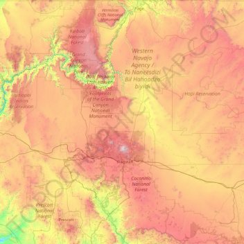
Name: Coconino County topographic map, elevation, terrain.

Location: Coconino County, Arizona, United States (34.25842 -113.35418 37.00303 -110.75065)

Average elevation: 1,725 m

Minimum elevation: 502 m

Maximum elevation: 3,723 m

Other topographic maps

Click on a map to view its topography, its elevation and its terrain.

Big A Mountain

United States > Arizona > Navajo County > Whiteriver

Average elevation: 1,693 m

Scottsdale

United States > Arizona > Maricopa County > Scottsdale

The city is in the Salt River Valley, or the "Valley of the Sun," in the northern reaches of the Sonoran Desert. Scottsdale, 31 mi (50 km) long and 11.4 mi (18.3 km) wide at its widest point, shares boundaries with many other municipalities and entities. On the west, Scottsdale is bordered by Phoenix, Paradise…

Average elevation: 414 m

Hoover Dam

United States > Arizona > Mohave County

The amount of electricity generated by Hoover Dam has been decreasing along with the falling water level in Lake Mead due to the prolonged drought since year 2000 and high demand for the Colorado River's water. By 2014 its generating capacity was downrated by 23% to 1592 MW and was providing power only during…

Average elevation: 429 m

Yuma

United States > Arizona > Yuma County

Average elevation: 69 m

Oak Creek Canyon

United States > Arizona > Coconino County

Oak Creek Canyon is about 12 miles (19 km) long, ranging in width from 0.8 to 2.5 miles (1.3 to 4.0 km). The depth of the canyon ranges from 800 to 2,000 feet (240 to 610 m). However, due to the faulting that played a major role in its formation, the west rim of the canyon is 700 feet (210 m) higher than the…

Average elevation: 1,859 m

Hassayampa

United States > Arizona > Maricopa County

Average elevation: 265 m

Oak Creek Canyon

United States > Arizona > Coconino County

Oak Creek Canyon is about 12 miles (19 km) long, ranging in width from 0.8 to 2.5 miles (1.3 to 4.0 km). The depth of the canyon ranges from 800 to 2,000 feet (240 to 610 m). However, due to the faulting that played a major role in its formation, the west rim of the canyon is 700 feet (210 m) higher than the…

Average elevation: 1,859 m

Concho

United States > Arizona > Apache County

Average elevation: 1,844 m

Green Valley

United States > Arizona > Pima County > Sahuarita

Average elevation: 962 m

San Tan Valley

United States > Arizona > Pinal County

Average elevation: 463 m

Grand Canyon

United States > Arizona > Coconino County

Uplift associated with mountain formation later moved these sediments thousands of feet upward and created the Colorado Plateau. The higher elevation has also resulted in greater precipitation in the Colorado River drainage area, but not enough to change the Grand Canyon area from being semi-arid. The uplift…

Average elevation: 1,023 m

Hungry Valley

United States > Arizona > Mohave County

Average elevation: 1,177 m

Marble Canyon

United States > Arizona > Coconino County

Average elevation: 1,102 m

Vail

United States > Arizona > Pima County > Vail

Average elevation: 1,035 m

Black Mesa

United States > Arizona > Mohave County

Average elevation: 1,037 m

St. Johns

United States > Arizona > Maricopa County > Komatke

Average elevation: 311 m

Colorado Spring

United States > Arizona > Mohave County

Average elevation: 884 m

Cathedral Rock

United States > Arizona > Yavapai County

Cathedral Rock is a natural sandstone butte near Sedona, Arizona, and one of the most-photographed sights in Arizona, United States. The rock formation is located in the Coconino National Forest in Yavapai County, about 1 mi (1.6 km) west of Arizona Route 179, and about 2.5 mi (4.0 km) south of the "Y"…

Average elevation: 1,282 m

Arizona City

United States > Arizona > Pinal County > Arizona City

Arizona City itself is mostly flat, lying in the Santa Cruz Valley in the center of three low mountain ranges; the Sawtooth Mountains to the south, the Picacho Mountains to the east, and the Casa Grande Mountains to the north. Picacho Peak, a prominent peak with a summit elevation of 3,374 feet (1,028 m), is…

Average elevation: 459 m

Truxton

United States > Arizona > Mohave County

Average elevation: 1,330 m

Needed Tank

United States > Arizona > Yavapai County

Average elevation: 1,763 m

Cow Springs

United States > Arizona > Coconino County

Cow Springs is a populated place situated in Coconino County, Arizona, United States. It has an estimated elevation of 5,863 feet (1,787 m) above sea level.

Average elevation: 1,788 m

Portal

United States > Arizona > Cochise County

Average elevation: 1,523 m

Fort McDonald

United States > Arizona > Gila County > Payson

Average elevation: 1,515 m

Bear Canyon Lake

United States > Arizona > Coconino County

Average elevation: 2,349 m

Spider Rock

United States > Arizona > Apache County

Average elevation: 1,954 m

Grand Canyon

United States > Arizona > Coconino County

Uplift associated with mountain formation later moved these sediments thousands of feet upward and created the Colorado Plateau. The higher elevation has also resulted in greater precipitation in the Colorado River drainage area, but not enough to change the Grand Canyon area from being semi-arid. The uplift…

Average elevation: 1,023 m

Wilhoit

United States > Arizona > Yavapai County

Average elevation: 1,416 m

Indian Gardens

United States > Arizona > Coconino County

Average elevation: 1,694 m

Saddlebrooke

United States > Arizona > Pinal County

Average elevation: 1,029 m

Mogollon Rim

United States > Arizona > Coconino County

Average elevation: 1,990 m

Valle Vista

United States > Arizona > Mohave County

Average elevation: 991 m

Fort McDowell

United States > Arizona > Maricopa County

Average elevation: 447 m

Wild Horse Mesa

United States > Arizona > Coconino County

Average elevation: 1,284 m

Windy Point

United States > Arizona > Pima County

Average elevation: 1,847 m

Topock

United States > Arizona > Mohave County

Average elevation: 180 m

Grand Canyon

United States > Arizona > Coconino County

Uplift associated with mountain formation later moved these sediments thousands of feet upward and created the Colorado Plateau. The higher elevation has also resulted in greater precipitation in the Colorado River drainage area, but not enough to change the Grand Canyon area from being semi-arid. The uplift…

Average elevation: 1,023 m

Fortuna Foothills

United States > Arizona > Yuma County

Average elevation: 113 m

Packer (Site)

United States > Arizona > Yavapai County

Average elevation: 1,328 m

Long Valley

United States > Arizona > Coconino County

Average elevation: 2,156 m

Marcou Mesa

United States > Arizona > Navajo County

Average elevation: 1,709 m

Iron Springs

United States > Arizona > Yavapai County

Average elevation: 1,828 m

East Mesa

United States > Arizona > Apache County

Average elevation: 2,093 m

Lake Montezuma

United States > Arizona > Yavapai County > Rimrock

Average elevation: 1,084 m

Roden Crater

United States > Arizona > Coconino County

Average elevation: 1,497 m

Roll

United States > Arizona > Yuma County

Average elevation: 80 m

Willow Beach

United States > Arizona > Mohave County

Average elevation: 321 m

Greenback Peak

United States > Arizona > Gila County

Average elevation: 1,680 m

Benton Tank

United States > Arizona > Greenlee County

Average elevation: 1,701 m

Lizard Rock

United States > Arizona > Pima County

Average elevation: 2,041 m

Portal

United States > Arizona > Cochise County

Average elevation: 1,523 m

Corona de Tucson

United States > Arizona > Pima County

Average elevation: 1,027 m

Fort Mohave

United States > Arizona > Mohave County

Average elevation: 183 m

Pinetop

United States > Arizona > Navajo County > Pinetop-Lakeside

Average elevation: 2,141 m

China Peak

United States > Arizona > Graham County

Average elevation: 1,155 m

Continental

United States > Arizona > Pima County > Green Valley

Average elevation: 888 m

Crystal Beach

United States > Arizona > Mohave County

Average elevation: 172 m

Vail

United States > Arizona > Pima County > Vail

Average elevation: 1,035 m

Monument Valley

United States > Arizona > Navajo County

The area is part of the Colorado Plateau. The elevation of the valley floor ranges from 5,000 to 6,000 feet (1,500 to 1,800 m) above sea level. The floor is largely siltstone of the Cutler Group, or sand derived from it, deposited by the meandering rivers that carved the valley. The valley's vivid red color…

Average elevation: 1,675 m

Pascua Pueblo

United States > Arizona > Pima County

Average elevation: 793 m

White Hills

United States > Arizona > Mohave County

Average elevation: 1,112 m

Mobile

United States > Arizona > Maricopa County > Goodyear

Average elevation: 402 m

Havasupai Gardens

United States > Arizona > Coconino County

Average elevation: 1,333 m

Dateland

United States > Arizona > Yuma County

Average elevation: 134 m

Thumb

United States > Arizona > Mohave County

Average elevation: 1,160 m

Sunset Crater

United States > Arizona > Coconino County

Average elevation: 2,168 m

Marble Canyon

United States > Arizona > Coconino County

Average elevation: 1,102 m

Heber-Overgaard

United States > Arizona > Navajo County

Heber-Overgaard is a census-designated place (CDP) in Navajo County, Arizona, United States. Situated atop the Mogollon Rim, the community lies at an elevation of 6,627 feet (2,020 m). The population was 2,898 at the 2020 census. Heber and Overgaard are technically two unincorporated communities, but as of the…

Average elevation: 2,015 m

San Tan Valley

United States > Arizona > Pinal County

Average elevation: 463 m

River Island

United States > Arizona > Mohave County

Average elevation: 459 m

Whetstone

United States > Arizona > Cochise County > Whetstone

Average elevation: 1,338 m

Wilhoit

United States > Arizona > Yavapai County

Average elevation: 1,520 m

Golden Valley

United States > Arizona > Mohave County

Average elevation: 864 m

Audley

United States > Arizona > Yavapai County

Average elevation: 1,589 m

Rocky Point

United States > Arizona > Maricopa County

Average elevation: 396 m

Woods Canyon Lake

United States > Arizona > Coconino County

Average elevation: 2,321 m

El Mirage

United States > Arizona > Maricopa County

Average elevation: 352 m

Dude Mountain

United States > Arizona > Coconino County > Williams

Average elevation: 2,146 m

Saddlebrooke

United States > Arizona > Pinal County

Average elevation: 1,029 m

Sun Valley

United States > Arizona > Navajo County

Average elevation: 1,615 m

Skull Valley

United States > Arizona > Yavapai County

Average elevation: 1,342 m

Peeples Valley

United States > Arizona > Yavapai County

Average elevation: 1,472 m

Beaver Dam

United States > Arizona > Mohave County

Average elevation: 596 m

Le Fevre Overlook

United States > Arizona > Coconino County

Average elevation: 2,032 m

Yaki Point

United States > Arizona > Coconino County

Average elevation: 1,774 m

Three Sisters

United States > Arizona > Navajo County

The area is part of the Colorado Plateau. The elevation of the valley floor ranges from 5,000 to 6,000 feet (1,500 to 1,800 m) above sea level. The floor is largely siltstone of the Cutler Group, or sand derived from it, deposited by the meandering rivers that carved the valley. The valley's vivid red color…

Average elevation: 1,664 m

Heber-Overgaard

United States > Arizona > Navajo County

Heber-Overgaard is a census-designated place (CDP) in Navajo County, Arizona, United States. Situated atop the Mogollon Rim, the community lies at an elevation of 6,627 feet (2,020 m). The population was 2,898 at the 2020 census. Heber and Overgaard are technically two unincorporated communities, but as of the…

Average elevation: 2,015 m

Antelope Canyon

United States > Arizona > Coconino County

Average elevation: 1,205 m

Rimrock

United States > Arizona > Yavapai County

Average elevation: 1,092 m

Waddell

United States > Arizona > Maricopa County

Average elevation: 369 m

Michigan Lake

United States > Arizona > Apache County

Average elevation: 1,888 m