Geolocate

Yuma topographic map

Click on the map to display elevation.

About this map

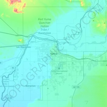
Name: Yuma topographic map, elevation, terrain.

Location: Yuma, Yuma County, Arizona, 85364, United States (32.53265 -114.78754 32.85265 -114.46754)

Average elevation: 69 m

Minimum elevation: 26 m

Maximum elevation: 508 m

Other topographic maps

Click on a map to view its topography, its elevation and its terrain.

Yuma

United States > Arizona > Yuma County

Average elevation: 56 m

San Luis

United States > Arizona > Yuma County

Average elevation: 36 m

Dateland

United States > Arizona > Yuma County

Average elevation: 134 m

Wellton

United States > Arizona > Yuma County

Average elevation: 97 m

Mittry Lake

United States > Arizona > Yuma County > Laguna

Average elevation: 58 m

Yuma

United States > Arizona > Yuma County

Average elevation: 56 m

Somerton

United States > Arizona > Yuma County

Average elevation: 33 m

Dateland

United States > Arizona > Yuma County

Average elevation: 134 m

Yuma

United States > Arizona > Yuma County

Average elevation: 56 m

Yuma

United States > Arizona > Yuma County

Average elevation: 56 m

Gear up for your next adventure:

🧶550 Survival Paracord - Versatile utility cord for emergency repairs and rigging
🧥Softshell Hiking Jacket - The perfect balance of wind protection and breathability
🔭Outdoor Binoculars - Lightweight binoculars for birdwatching and hiking
🧼Travel Hand Sanitizer - Keep hands clean when water is scarce
❄️Traction Ice Cleats - Slip-on spikes for icy trails and winter hiking

As an Amazon Associate, this site earns from qualifying purchases at no extra cost to you.