Geolocate

Topock topographic map

Click on the map to display elevation.

About this map

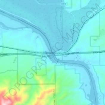
Name: Topock topographic map, elevation, terrain.

Location: Topock, Mohave County, Arizona, United States (34.69860 -114.50391 34.73860 -114.46391)

Average elevation: 180 m

Minimum elevation: 137 m

Maximum elevation: 445 m

Gear up for your next adventure:

🧼Travel Hand Sanitizer - Keep hands clean when water is scarce
🚑Survival Whistle - Signal for help across long distances in mountains
🧢Hiking Sun Hat - Wide-brimmed protection for exposed mountain ridges
Camping Groundsheet - Protect your tent from moisture and dirt
🧤Insulated Winter Gloves - Heavy-duty protection for sub-zero Canadian adventures

As an Amazon Associate, this site earns from qualifying purchases at no extra cost to you.