Geolocate

Whetstone topographic map

Click on the map to display elevation.

About this map

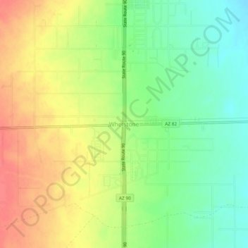
Name: Whetstone topographic map, elevation, terrain.

Location: Whetstone, Cochise County, Arizona, United States (31.67287 -110.37029 31.71287 -110.33029)

Average elevation: 1,338 m

Minimum elevation: 1,310 m

Maximum elevation: 1,367 m

Gear up for your next adventure:

🔪Outdoor Multitool - Versatile tool for repairs and food prep in the wild
🗺️Topographic Maps - Detailed maps to explore trails, mountains, and wilderness areas
💧Collapsible Water Bottle - Space-saving water bottle for outdoor activities
🦟Insect Repellent - Keep mosquitoes and black flies away in wooded areas
🧭GPS Tracker - Track your location in remote areas safely

As an Amazon Associate, this site earns from qualifying purchases at no extra cost to you.