
Hoover Dam topographic map
Click on the map to display elevation.
Hoover Dam
The amount of electricity generated by Hoover Dam has been decreasing along with the falling water level in Lake Mead due to the prolonged drought since year 2000 and high demand for the Colorado River's water. By 2014 its generating capacity was downrated by 23% to 1592 MW and was providing power only during periods of peak demand. Lake Mead fell to a new record low elevation of 1,071.61 feet (326.63 m) on July 1, 2016, before beginning to rebound slowly. Under its original design, the dam would no longer be able to generate power once the water level fell below 1,050 feet (320 m), which might have occurred in 2017 had water restrictions not been enforced. To lower the minimum power pool elevation from 1,050 to 950 feet (320 to 290 m), five wide-head turbines, designed to work efficiently with less flow, were installed. Water levels were maintained at over 1,075 feet (328 m) in 2018 and 2019, but fell to a new record low of 1,071.55 feet (326.61 m) on June 10, 2021 and were projected to fall below 1,066 feet (325 m) by the end of 2021.
About this map
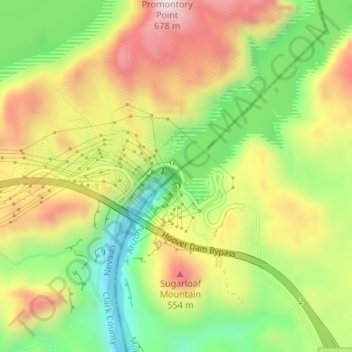
Name: Hoover Dam topographic map, elevation, terrain.
Location: Hoover Dam, Mohave County, Arizona, United States (36.01474 -114.73939 36.01669 -114.73674)
Average elevation: 429 m
Minimum elevation: 197 m
Maximum elevation: 682 m
Other topographic maps
Click on a map to view its topography, its elevation and its terrain.
Bullhead City
United States > Arizona > Mohave County
Hardyville Pioneer Cemetery, a small cemetery, now a historic landmark at 35°7′16″N 114°35′17″W / 35.12111°N 114.58806°W / 35.12111; -114.58806, is the most significant existing remnant of Hardyville. An unofficial historical marker for the town is in the parking lot across Highway 95 from…
Average elevation: 328 m
Antares
United States > Arizona > Mohave County > Antares
Antares is located in northwestern Arizona, in central Mohave County, 21 miles (34 km) northeast of Kingman, the county seat. The Antares census-designated place encompasses 0.65 square miles (1.7 km2) of land, and is at 3,556 feet (1,084 m) elevation above sea level. The southern edge of the CDP follows State…
Average elevation: 1,060 m
Oatman
United States > Arizona > Mohave County
Oatman is a census-designated place (CDP) in the Black Mountains of Mohave County, Arizona, United States, at an elevation of 2,710 feet (830 m). In 1915, it began as a small mining camp when two prospectors struck US$10 million (equivalent to $176 million in 2024) in gold, though the vicinity had already been…
Average elevation: 894 m
Mount Trumbull Wilderness
United States > Arizona > Mohave County
At lower elevations the vegetation of the wilderness consists of Utah juniper (Juniperus osteosperma), pinyon pine, Mojave yucca (Yucca schidigera), and sagebrush (Artemisia tridentata). Moving up, the vegetation slowly changes into ponderosa pines. The area was heavily logged in the late 19th century…
Average elevation: 1,973 m
Kingman
United States > Arizona > Mohave County
Lt. Edward Fitzgerald Beale, a U.S. Navy officer in the service of the Army Corps of Topographical Engineers, was ordered by the U.S. War Department to build a federal wagon road across the 35th parallel. His secondary orders were to test the feasibility of the use of camels as pack animals in the Southwestern…
Average elevation: 1,131 m
Pigeon Point Lighthouse
United States > Arizona > Mohave County > Lake Havasu City
Average elevation: 155 m
Bullhead City
United States > Arizona > Mohave County
Hardyville Pioneer Cemetery, a small cemetery, now a historic landmark at 35°7′16″N 114°35′17″W / 35.12111°N 114.58806°W / 35.12111; -114.58806, is the most significant existing remnant of Hardyville. An unofficial historical marker for the town is in the parking lot across Highway 95 from…
Average elevation: 322 m
Bullhead City
United States > Arizona > Mohave County
Hardyville Pioneer Cemetery, a small cemetery, now a historic landmark at 35°7′16″N 114°35′17″W / 35.12111°N 114.58806°W / 35.12111; -114.58806, is the most significant existing remnant of Hardyville. An unofficial historical marker for the town is in the parking lot across Highway 95 from…
Average elevation: 328 m
Kingman
United States > Arizona > Mohave County
Lt. Edward Fitzgerald Beale, a U.S. Navy officer in the service of the Army Corps of Topographical Engineers, was ordered by the U.S. War Department to build a federal wagon road across the 35th parallel. His secondary orders were to test the feasibility of the use of camels as pack animals in the Southwestern…
Average elevation: 1,130 m