Geolocate

Vail topographic map

Click on the map to display elevation.

About this map

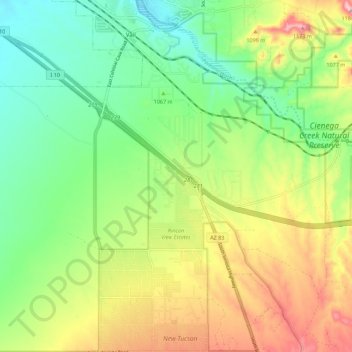
Name: Vail topographic map, elevation, terrain.

Location: Vail, Pima County, Arizona, United States (31.96314 -110.72319 32.05694 -110.63730)

Average elevation: 1,035 m

Minimum elevation: 945 m

Maximum elevation: 1,176 m

Gear up for your next adventure:

🧥Thermal Layer - Insulating layer for cold outdoor conditions
💧Reusable Water Bottle - Durable water bottles for hydration on trails
💧Filtered Water Bottle - Safe drinking water on the go
🎒Hiking Daypack - Lightweight and durable backpacks for day trips and excursions
🛏️Sleeping Bag - Warm and compact sleeping bags for outdoor camping

As an Amazon Associate, this site earns from qualifying purchases at no extra cost to you.