Geolocate

Ottawa topographic map

Click on the map to display elevation.

Ottawa

Ottawa, the capital city of Canada, is situated on the south bank of the Ottawa River at the confluence with the Rideau River. The city's topography is characterized by gently rolling terrain with elevations ranging from approximately 44 meters (144 feet) above sea level at the Ottawa River to its highest point of 166 meters (545 feet), located 2.6 kilometers (1.62 miles) south-southeast of Manion Corners. The landscape is predominantly composed of Paleozoic carbonate and shale lowlands, surrounded by more rugged Precambrian igneous and metamorphic formations. Notably, the nearby Gatineau Hills, part of the southern tip of the Canadian Shield, rise across the Ottawa River in Quebec, providing a contrasting hilly backdrop to the otherwise moderate relief of the Ottawa Valley.

About this map

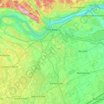
Name: Ottawa topographic map, elevation, terrain.

Location: Ottawa, Eastern Ontario, Ontario, Canada (44.96177 -76.35559 45.53765 -75.24658)

Average elevation: 105 m

Minimum elevation: 38 m

Maximum elevation: 409 m

Ontario trails, hiking, mountain biking, running and outdoor activities

Other topographic maps

Click on a map to view its topography, its elevation and its terrain.

Toronto

Canada > Ontario > Toronto

Despite its deep ravines, Toronto is not remarkably hilly, but its elevation does increase steadily away from the lake. Elevation differences range from 76.5 metres (251 ft) above sea level at the Lake Ontario shore to 209 m (686 ft) ASL near the York University grounds in the city's north end at the…

Average elevation: 113 m

London

Canada > Ontario > London > London

London has a humid continental climate (Köppen Dfb), though due to its downwind location relative to Lake Huron and elevation changes across the city, it is virtually on the Dfa/Dfb (hot summer) boundary favouring the former climate zone to the southwest of the confluence of the South and North Thames Rivers,…

Average elevation: 268 m

Peterborough

Canada > Ontario > Peterborough

Peterborough's topography is largely defined by land formations created by the receding Wisconsian glaciers 10,000–15,000 years ago. The South End and Downtown portions of the City sit on what was the bottom of the glacial Lake Peterborough—part of a glacial spillway created when glacial meltwaters from…

Average elevation: 235 m

Hamilton

Canada > Ontario > Hamilton

Average elevation: 181 m

Kingston

Canada > Ontario > Kingston

Average elevation: 94 m

Guelph

Canada > Ontario > Guelph

This region of Ontario has cold winters and warm, humid summers, falling into the Köppen climate classification Dfb zone, with moderately high rainfall and snowfall. It is generally a couple of degrees cooler than lower elevation regions on the Great Lakes shorelines, especially so in winter, the exception…

Average elevation: 344 m

Kenora

Canada > Ontario

Average elevation: 182 m

Niagara Escarpment

Canada > Ontario

Average elevation: 299 m

Windsor

Canada > Ontario > Windsor

Average elevation: 185 m

Calabogie

Canada > Ontario > Renfrew County > Greater Madawaska

Average elevation: 163 m

King City

Canada > Ontario > York Region > King

Average elevation: 302 m

Conestoga Lake

Canada > Ontario > Wellington County > Mapleton

Average elevation: 412 m

Haliburton

Canada > Ontario

Average elevation: 358 m

Belleville

Canada > Ontario > Belleville

Average elevation: 107 m

Bruce Peninsula

Canada > Ontario > Grey County > Georgian Bluffs

Average elevation: 240 m

Rattlesnake Point

Canada > Ontario > Milton

Average elevation: 244 m

Niagara Escarpment

Canada > Ontario > Hamilton

Average elevation: 162 m

Curve Lake

Canada > Ontario > Peterborough County

Average elevation: 249 m

Green Lake

Canada > Ontario > Renfrew County > Greater Madawaska

Average elevation: 294 m

Brownsville

Canada > Ontario > Durham Region > Clarington > Newcastle

Average elevation: 143 m

Moose Factory

Canada > Ontario > Cochrane District

Average elevation: 5 m

Quetico Provincial Park

Canada > Ontario

Average elevation: 432 m

St. Jacobs

Canada > Ontario > Region of Waterloo > Woolwich

Average elevation: 341 m

Port Perry

Canada > Ontario > Durham Region > Scugog

Average elevation: 263 m

Rockwood

Canada > Ontario > Wellington County > Guelph/Eramosa

Average elevation: 364 m

Terra Cotta

Canada > Ontario > Peel Region > Caledon

Average elevation: 281 m

Brantford

Canada > Ontario > Brantford

Average elevation: 238 m

Stratford

Canada > Ontario > Stratford

Average elevation: 356 m

Gull Lake

Canada > Ontario > Haliburton County > Minden Hills

Average elevation: 281 m

Parry Sound

Canada > Ontario

Average elevation: 235 m

Southampton

Canada > Ontario > Bruce County

Average elevation: 190 m

Coldwater

Canada > Ontario > Simcoe County > Severn

Average elevation: 196 m

Port Dover

Canada > Ontario > Norfolk County

Average elevation: 187 m

Dundas

Canada > Ontario > Hamilton > Dundas

Dundas /ˈdʌnˌdæs/ is a community and former town in Hamilton, Ontario, Canada. It is nicknamed the Valley Town because of its topographical location at the bottom of the Niagara Escarpment on the western edge of Lake Ontario. The population has been stable for decades at about twenty thousand, largely…

Average elevation: 171 m

Grand Bend

Canada > Ontario > Lambton County > Lambton Shores

Average elevation: 183 m

Tiverton

Canada > Ontario > Bruce County > Kincardine

Average elevation: 236 m

Hamilton Mountain

Canada > Ontario > Hamilton

Average elevation: 164 m

Lake of Bays

Canada > Ontario > Muskoka District

Average elevation: 341 m

Niagara Escarpment

Canada > Ontario > Bruce County

Average elevation: 195 m

Belfountain

Canada > Ontario > Peel Region > Caledon

Average elevation: 393 m

Nottawasaga Bay

Canada > Ontario > Simcoe County > Tiny

Average elevation: 175 m

Maitland River

Canada > Ontario > Huron County > Howick > Gorrie

Average elevation: 348 m

Eels Lake

Canada > Ontario > Peterborough County > North Kawartha

Average elevation: 361 m

Victoria Harbour

Canada > Ontario > Simcoe County > Tay

Average elevation: 185 m

Belle River

Canada > Ontario > Essex County

Average elevation: 177 m

Elmira

Canada > Ontario > Region of Waterloo > Woolwich

Average elevation: 362 m

Turkey Point

Canada > Ontario > Norfolk County

Average elevation: 187 m

Cambridge

Canada > Ontario > Cambridge

Average elevation: 295 m

Prince Edward

Canada > Ontario

Average elevation: 118 m

Perth

Canada > Ontario

Average elevation: 313 m

Lambton

Canada > Ontario

Average elevation: 188 m

Essex

Canada > Ontario

Average elevation: 193 m

St. Thomas

Canada > Ontario > St. Thomas

Average elevation: 231 m

Tobermory

Canada > Ontario > Northern Bruce Peninsula > Tobermory

The deep waters at the mouth of Georgian Bay are home to Fathom Five, Canada's first National Marine Conservation Area. The park preserves a rich cultural legacy that includes 22 shipwrecks and several historic lighthouses. Fathom Five's freshwater ecosystem contains some of the most pristine waters of the…

Average elevation: 182 m

Lac Seul

Canada > Ontario

Average elevation: 365 m

Harlem Shoal

Canada > Ontario

Average elevation: 175 m

St. Johns

Canada > Ontario

Average elevation: 205 m

Niagara Escarpment

Canada > Ontario > Burlington

Average elevation: 216 m

Balsam Lake

Canada > Ontario > Kawartha Lakes

Average elevation: 257 m

Keswick

Canada > Ontario > York Region

Keswick's geographical coordinates are 44.22°N, 79.45°W, and its elevation above sea level is 221m/762 ft. It has a geographical area of 16.25 km² according to Statistics Canada. It is bound on the north by Roches Point, the east by Woodbine Avenue, the south by East Gwillimbury (Ravenshoe Road) and the…

Average elevation: 228 m

Ohsweken

Canada > Ontario

Average elevation: 208 m

Sagamok

Canada > Ontario

Average elevation: 210 m

Pinehurst Lake

Canada > Ontario

Average elevation: 295 m

Docker Lake

Canada > Ontario

Average elevation: 377 m

Oneida Nation of the Thames

Canada > Ontario

Average elevation: 224 m

Bigwin Island

Canada > Ontario

Average elevation: 328 m

Upper Pergeon Lake

Canada > Ontario

Average elevation: 215 m

Achigan Lake

Canada > Ontario > Unorganized North Algoma

Average elevation: 377 m

York River

Canada > Ontario

Average elevation: 397 m

Kawartha Lakes (city)

Canada > Ontario

Average elevation: 274 m

Pelee Island

Canada > Ontario

Average elevation: 173 m

Quinte West (city)

Canada > Ontario

Average elevation: 160 m

London

Canada > Ontario

London has a humid continental climate (Köppen Dfb), though due to its downwind location relative to Lake Huron and elevation changes across the city, it is virtually on the Dfa/Dfb (hot summer) boundary favouring the former climate zone to the southwest of the confluence of the South and North Thames Rivers,…

Average elevation: 269 m

Lambton

Canada > Ontario

Average elevation: 191 m

Algoma District

Canada > Ontario

Average elevation: 360 m

London (city)

Canada > Ontario

Average elevation: 239 m

Beaverton

Canada > Ontario > Durham Region > Brock

Average elevation: 231 m

Coniston

Canada > Ontario > Sudbury District > Greater Sudbury

Average elevation: 264 m

Kawartha Lakes

Canada > Ontario > Kawartha Lakes

Average elevation: 269 m

Doe Lake

Canada > Ontario > Muskoka District > Gravenhurst

Average elevation: 271 m

Sky Zone

Canada > Ontario > Niagara Region > St. Catharines

Average elevation: 96 m

Gear up for your next adventure:

🦶Hiking Shoe Insoles - Added support for high arches and long days on feet
🥾Hiking Shorts - Breathable shorts suitable for summer hikes
🥫Freeze-Dried Meals - Lightweight, high-calorie nutrition for multi-day treks
🔦LED Flashlight - Powerful and long-lasting flashlight for camping and emergencies
🥘Camping Cookware Set - Compact nesting pots and pans for trail cooking

As an Amazon Associate, this site earns from qualifying purchases at no extra cost to you.