
Make a donation
Gear up for your next adventure:
As an Amazon Associate, this site earns from qualifying purchases at no extra cost to you.
Salmon Lake topographic map
Click on the map to display elevation.
Make a donation
Gear up for your next adventure:
As an Amazon Associate, this site earns from qualifying purchases at no extra cost to you.
About this map
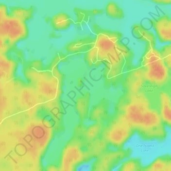
Name: Salmon Lake topographic map, elevation, terrain.
Average elevation: 220 m
Minimum elevation: 200 m
Maximum elevation: 239 m
Parry Sound District trails, hiking, mountain biking, running and outdoor activities
Make a donation
Gear up for your next adventure:
As an Amazon Associate, this site earns from qualifying purchases at no extra cost to you.
Other topographic maps
Click on a map to view its topography, its elevation and its terrain.
Diamond Lake
Canada > Ontario > Parry Sound District > Seguin Township > Orrville
Average elevation: 273 m
Make a donation
Gear up for your next adventure:
As an Amazon Associate, this site earns from qualifying purchases at no extra cost to you.
Oastler Lake Provincial Park
Canada > Ontario > Parry Sound District > Seguin Township
Average elevation: 218 m