Geolocate

Stratford topographic map

Click on the map to display elevation.

About this map

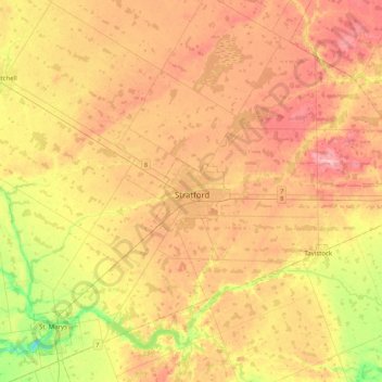
Name: Stratford topographic map, elevation, terrain.

Location: Stratford, Southwestern Ontario, Ontario, N5A 3K2, Canada (43.21009 -81.14180 43.53009 -80.82180)

Average elevation: 356 m

Minimum elevation: 280 m

Maximum elevation: 420 m

Ontario trails, hiking, mountain biking, running and outdoor activities

Gear up for your next adventure:

🔪Outdoor Multitool - Versatile tool for repairs and food prep in the wild
🥾Waterproof Trail Shoes - Shoes designed to handle wet terrain
🔦LED Headlamp - Hands-free lighting for early morning starts or late finishes
🛶Canoe Life Vest - Safety vest for water sports
💡Portable Camping Lamp - Rechargeable lamp for campsite lighting

As an Amazon Associate, this site earns from qualifying purchases at no extra cost to you.