
Baden-Württemberg topographic map
Interactive map
Click on the map to display elevation.
Baden-Württemberg
The climate across the states varies. This is mostly due to a high amount of mountains and highlands inside of the state. Most parts in the western parts (Baden) lower than 500–800 metres (1,600–2,600 ft) enjoy an almost year round mild oceanic climate (cfb in Köppen classification). The climate in the eastern parts of the state is more continental. For instance, winters in the city of Ulm are colder than in Berlin. While winters in the warmest areas often lack snow, the Black Forest, Swabian Alb and the Alps tend to get snow frequently, especially in areas of high elevation. Summers here have more rain than in the valleys, but winters tend to have more sun.
About this map
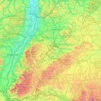
Name: Baden-Württemberg topographic map, elevation, terrain.
Location: Baden-Württemberg, Germany (47.53248 7.51175 49.79129 10.49557)
Average elevation: 442 m
Minimum elevation: 85 m
Maximum elevation: 1,846 m
Other topographic maps
Click on a map to view its topography, its elevation and its terrain.
Nabern
Germany > Baden-Württemberg > Landkreis Esslingen > Kirchheim unter Teck
Average elevation: 385 m
Lehnberg
Germany > Thuringia > Landkreis Nordhausen > Harztor > Herrmannsacker
Average elevation: 406 m
Niels
Germany > Mecklenburg-Vorpommern > Ludwigslust-Parchim > Bresegard bei Picher
Average elevation: 20 m
Sauerland
Germany > North Rhine – Westphalia
To the west the hills continue into the Bergisches Land, to the south into the Siegerland, and to the north-east into the Teutoburg Forest. The major rivers of the Sauerland are the Ruhr and the Lenne. Several artificial lakes were created on the smaller rivers by building dams to store water for the nearby…
Average elevation: 316 m
Ginsburg
Germany > North Rhine – Westphalia > Kreis Siegen-Wittgenstein > Hilchenbach
The town's largest flowing body of water is the Ferndorfbach, a tributary to the river Sieg. The municipal area's average elevation is 427 metres (1,401 ft) above sea level, with its highest elevation being at 678 metres (2,224 ft) at the Riemen, a peak in the Rothaargebirge.
Average elevation: 510 m
Kierdorf
Germany > North Rhine-Westphalia > Rheinisch-Bergischer Kreis > Bergisch Gladbach > Herkenrath
Average elevation: 189 m
Klein Bengerstorf
Germany > Mecklenburg-Vorpommern > Ludwigslust-Parchim > Bengerstorf
Average elevation: 24 m
Berlin
Berlin straddles the banks of the River Spree, which flows into the River Havel (a tributary of the River Elbe) in the western borough of Spandau. Among the city's main topographical features are the many lakes in the western and southeastern boroughs formed by the Spree, Havel, and Dahme rivers (the largest…
Average elevation: 47 m
Clünder
Germany > Lower Saxony > Landkreis Rotenburg (Wümme) > Horstedt > Clünder
Average elevation: 29 m
Markt Schwaben
Germany > Bavaria > Landkreis Ebersberg > Markt Schwaben > Markt Schwaben
Average elevation: 513 m
Mainz
Germany > Rhineland-Palatinate > Mainz
Nevertheless, the post-war reconstruction took place very slowly. While cities such as Frankfurt had been rebuilt fast by a central authority, only individual efforts were initially successful in rebuilding Mainz. The reason for this was that the French wanted Mainz to expand and to become a model city. Mainz…
Average elevation: 183 m
Eisenach
Germany > Thuringia > Eisenach
Eisenach is situated at the northern edge of the Thuringian Forest, at an elevation of about 220 m. The terrain is hilly, to the south also mountainous (up to 460 m of elevation), with the central Hörsel valley crossing the town in east-western direction. The Nesse river enters the Hörsel river in Eisenach…
Average elevation: 290 m
Tromsdorf
Germany > Saxony-Anhalt > Burgenlandkreis > Eckartsberga > Tromsdorf
Average elevation: 195 m
Hanover
Germany > Lower Saxony > Region Hannover > Hanover
In 1636 George, Duke of Brunswick-Lüneburg, ruler of the Brunswick-Lüneburg principality of Calenberg, moved his residence to Hanover. The Dukes of Brunswick-Lüneburg were elevated by the Holy Roman Emperor to the rank of Prince-Elector in 1692 and this elevation was confirmed by the Imperial Diet in 1708.…
Average elevation: 70 m
Kleinberg
Germany > Bavaria > Landkreis Neustadt an der Waldnaab > Kirchendemenreuth
Average elevation: 471 m
Winterberg
Germany > North Rhine-Westphalia > Hochsauerlandkreis > Winterberg > Winterberg
Average elevation: 648 m
NSG Wiesen am Hirtenborn
Germany > Rhineland-Palatinate > Landkreis Mainz-Bingen > Manubach
Average elevation: 447 m