Geolocate

Ingolstadt topographic map

Click on the map to display elevation.

About this map

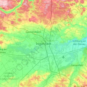
Name: Ingolstadt topographic map, elevation, terrain.

Location: Ingolstadt, Bavaria, 85057, Germany (48.60302 11.26504 48.92302 11.58504)

Average elevation: 409 m

Minimum elevation: 348 m

Maximum elevation: 553 m

Gear up for your next adventure:

🥾Approach Boots - Comfortable boots for hiking and climbing approaches
Bushcraft Tarp - Versatile emergency shelter or gear protection
💡Compact LED Flashlight - Powerful and portable flashlight for outdoor use
🪑Ultralight Camping Stool - Compact seating for rest stops during long hikes
🗺️Topographic Maps - Detailed maps to explore trails, mountains, and wilderness areas

As an Amazon Associate, this site earns from qualifying purchases at no extra cost to you.