
Make a donation
Gear up for your next adventure:
As an Amazon Associate, this site earns from qualifying purchases at no extra cost to you.
Allgäu topographic map
Click on the map to display elevation.
Make a donation
Gear up for your next adventure:
As an Amazon Associate, this site earns from qualifying purchases at no extra cost to you.
About this map
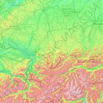
Name: Allgäu topographic map, elevation, terrain.
Location: Allgäu, Bavaria, 87509, Germany (46.59260 9.20916 48.59260 11.20916)
Average elevation: 1,087 m
Minimum elevation: 270 m
Maximum elevation: 3,582 m
Make a donation
Gear up for your next adventure:
As an Amazon Associate, this site earns from qualifying purchases at no extra cost to you.
Other topographic maps
Click on a map to view its topography, its elevation and its terrain.
Untersberg
Germany > Bavaria > Landkreis Berchtesgadener Land
Several trails lead to the top, though most people prefer the Untersbergbahn cable car. Constructed over a period of over two years, and opening in April 1961, the eight and a half minute journey lifts passengers from the lower terminus at the village of Sankt Leonhard at 456 m (1,496 ft) over 1,320 m (4,330…
Average elevation: 797 m
Wilhelmsdorf
Germany > Bavaria > Landkreis Neustadt an der Aisch-Bad Windsheim
Average elevation: 361 m
Make a donation
Gear up for your next adventure:
As an Amazon Associate, this site earns from qualifying purchases at no extra cost to you.
Zwiesel
Germany > Bavaria > Landkreis Regen
Zwiesel has an humid continental climate (Köppen: Dfb; Trewartha: Dclo). The Zwiesel weather station is located at an altitude of 615 m (2,018 ft). The temperature is significantly lower than in most parts of Germany by several degrees. At the same time, the average annual precipitation exceeds 1,000 mm (39…
Average elevation: 681 m
Ramsau bei Berchtesgaden
Germany > Bavaria > Landkreis Berchtesgadener Land
Average elevation: 1,302 m
Make a donation
Gear up for your next adventure:
As an Amazon Associate, this site earns from qualifying purchases at no extra cost to you.
Make a donation
Gear up for your next adventure:
As an Amazon Associate, this site earns from qualifying purchases at no extra cost to you.
Seubersdorf in der Oberpfalz
Germany > Bavaria > Landkreis Neumarkt in der Oberpfalz
Average elevation: 519 m
Make a donation
Gear up for your next adventure:
As an Amazon Associate, this site earns from qualifying purchases at no extra cost to you.
Make a donation
Gear up for your next adventure:
As an Amazon Associate, this site earns from qualifying purchases at no extra cost to you.
Make a donation
Gear up for your next adventure:
As an Amazon Associate, this site earns from qualifying purchases at no extra cost to you.
Murnau am Staffelsee
Germany > Bavaria > Landkreis Garmisch-Partenkirchen > Murnau am Staffelsee
Average elevation: 670 m
Watzmann
Germany > Bavaria > Landkreis Berchtesgadener Land > Ramsau bei Berchtesgaden
Average elevation: 1,177 m
Make a donation
Gear up for your next adventure:
As an Amazon Associate, this site earns from qualifying purchases at no extra cost to you.