
Hanover topographic map
Click on the map to display elevation.
Hanover
In 1636 George, Duke of Brunswick-Lüneburg, ruler of the Brunswick-Lüneburg principality of Calenberg, moved his residence to Hanover. The Dukes of Brunswick-Lüneburg were elevated by the Holy Roman Emperor to the rank of Prince-Elector in 1692 and this elevation was confirmed by the Imperial Diet in 1708. Thus the principality was upgraded to the Electorate of Hanover, colloquially known as the Electorate of Hanover after Calenberg's capital (see also: House of Hanover). Its Electors later become monarchs of Great Britain (and from 1801 of the United Kingdom of Great Britain and Ireland). The first of these was George I Louis, who acceded to the British throne in 1714. The last British monarch who reigned in Hanover was William IV. Semi-Salic law, which required succession by the male line if possible, forbade the accession of Queen Victoria in Hanover. As a male-line descendant of George I, Queen Victoria was herself a member of the House of Hanover. Her descendants, however, bore her husband's titular name of Saxe-Coburg-Gotha. Three kings of Great Britain, or the United Kingdom, were concurrently also Electoral Princes of Hanover.
About this map
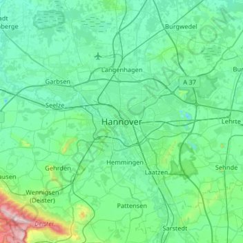
Name: Hanover topographic map, elevation, terrain.
Location: Hanover, Region Hannover, Lower Saxony, 30159, Germany (52.21448 9.57855 52.53448 9.89855)
Average elevation: 70 m
Minimum elevation: 22 m
Maximum elevation: 402 m