
Himachal Pradesh topographic map
Interactive map
Click on the map to display elevation.
About this map
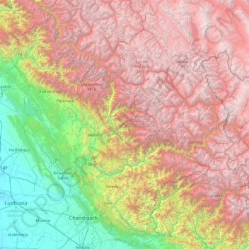
Name: Himachal Pradesh topographic map, elevation, terrain.
Location: Himachal Pradesh, India (30.37717 75.59401 33.25567 79.01238)
Average elevation: 2,869 m
Minimum elevation: 232 m
Maximum elevation: 6,687 m
Due to extreme variation in elevation, great variation occurs in the climatic conditions of Himachal. The climate varies from hot and humid subtropical in the southern tracts to, with more elevation, cold, alpine, and glacial in the northern and eastern mountain ranges.[29] The state's winter capital, Dharamsala receives very heavy rainfall, while areas like Lahaul and Spiti are cold and almost rainless. Broadly, Himachal experiences three seasons: summer, winter, and rainy season. Summer lasts from mid-April till the end of June and most parts become very hot (except in the alpine zone which experiences a mild summer) with the average temperature ranging from 28 to 32 °C (82 to 90 °F). Winter lasts from late November till mid-March. Snowfall is common in alpine tracts. Pollution is affecting the climate of almost all the states of India. Due to steps taken by governments to prevent pollution, Himachal Pradesh has become the first smoke-free state in India which means cooking in the entire state is free of traditional chulhas.[30]
Other topographic maps
Click on a map to view its topography, its elevation and its terrain.
Shahapur Taluka
Shahapur Taluka, Thane District, Maharashtra, India
Average elevation: 224 m
Nava Raipur
India > Chhattisgarh > Arang Tahsil
Nava Raipur, Arang Tahsil, Raipur District, Chhattisgarh, India
Average elevation: 305 m
Rajkot
India > Gujarat > Rajkot Taluka
Rajkot, Rajkot Taluka, Rajkot District, Gujarat, 360001, India
Average elevation: 141 m
Navi Mumbai
India > Maharashtra > Navi Mumbai
Navi Mumbai, Thane, Maharashtra, 400706, India
Average elevation: 30 m
Visakhapatnam
India > Andhra Pradesh > Visakhapatnam (Urban)
Visakhapatnam, Visakhapatnam (Urban), Visakhapatnam, Andhra Pradesh, 530001, India
Average elevation: 41 m
Saidabad
India > Rajasthan > Tonk Tehsil > Tonk
Saidabad, Tonk, Tonk Tehsil, Tonk District, Rajasthan, 304001, India
Average elevation: 273 m
Bewar
India > Uttar Pradesh > Bhogaon
Bewar, Bhogaon, Mainpuri District, Uttar Pradesh, 206300, India
Average elevation: 151 m
Lucknow
India > Uttar Pradesh > Lucknow
Lucknow, Lucknow District, Uttar Pradesh, 226027, India
Average elevation: 120 m
Tirupati
India > Andhra Pradesh > Tirupati (Urban)
Tirupati, Tirupati (Urban), Tirupati, Andhra Pradesh, 517500, India
Average elevation: 319 m
Kanchipuram
India > Tamil Nadu > Kanchipuram
Kanchipuram, Kancheepuram, Kanchipuram District, Tamil Nadu, 631501, India
Average elevation: 82 m
Vadodara Rural Taluka
Vadodara Rural Taluka, Vadodara District, Gujarat, India
Average elevation: 35 m
Deoli
India > Rajasthan > Deoli Tehsil
Deoli, Deoli Tehsil, Tonk District, Rajasthan, 323802, India
Average elevation: 332 m
Baba Bakala Tahsil
Baba Bakala Tahsil, Amritsar District, Punjab, India
Average elevation: 239 m
Tiruchirappalli
India > Tamil Nadu > Tiruchirappalli
Tiruchirappalli, Tiruchchirappalli district, Tamil Nadu, 620001, India
Average elevation: 83 m
Ponneri
India > Tamil Nadu > Ponneri
Ponneri, Thiruvallur District, Tamil Nadu, 601204, India
Average elevation: 10 m
Seelam Pur Tehsil
Seelam Pur Tehsil, North East Delhi District, Delhi, India
Average elevation: 208 m
Gandhinagar
India > Gujarat > Gandhinagar Taluka
Gandhinagar, Gandhinagar Taluka, Gandhinagar District, Gujarat, India
Average elevation: 75 m
Zemu Glacier
India > Sikkim > Chungthang
Zemu Glacier, Chungthang, Mangan District, Sikkim, India
Average elevation: 5,510 m
Chikhli
India > Gujarat > Chikhli Taluka
Chikhli, Chikhli Taluka, Navsari District, Gujarat, 396521, India
Average elevation: 23 m
Kaniyambādi
India > Tamil Nadu > Vellore
Kaniyambādi, Vellore, Vellore District, Tamil Nadu, 632102, India
Average elevation: 253 m
Rajpura
India > Rajasthan > Shahpura Tehsil
Rajpura, Shahpura Tehsil, Jaipur(Rural) District, Rajasthan, 303103, India
Average elevation: 451 m
Dudhsagar Falls
India > Goa > Dharbandora
Dudhsagar Falls, Dharbandora, South Goa District, Goa, India
Average elevation: 418 m
Sahaspur
India > Uttar Pradesh > Dhampur
Sahaspur, Dhampur, Bijnor District, Uttar Pradesh, 246745, India
Average elevation: 217 m
Lake Vasuki Tal
India > Uttarakhand > Ukhimath > Kedarnath
Lake Vasuki Tal, Kedarnath, Ukhimath, Rudraprayag District, Uttarakhand, India
Average elevation: 4,303 m
Ognaj
India > Gujarat > Ghatlodiya Taluka
Ognaj, Ghatlodiya Taluka, Ahmedabad District, Gujarat, 380060, India
Average elevation: 57 m
Ghatlodiya Taluka
Ghatlodiya Taluka, Ahmedabad District, Gujarat, India
Average elevation: 53 m
Collem
India > Goa > Dharbandora
Collem, Dharbandora, South Goa District, Goa, India
Average elevation: 90 m
Pratapsinghpura
India > Rajasthan > Neemrana Tehsil
Pratapsinghpura, Neemrana Tehsil, Kotputli-Behror District, Rajasthan, 301706, India
Average elevation: 309 m
Yaja
India > Arunachal Pradesh > Taksing Circle
Yaja, Taksing Circle, Upper Subansiri District, Arunachal Pradesh, India
Average elevation: 2,759 m
Burhanpur
Burhanpur, Azamgarh District, Uttar Pradesh, India
Average elevation: 82 m
Puducherry
India > Puducherry > Puducherry Taluk
Puducherry, Puducherry Taluk, Puducherry District, Puducherry, 605001, India
Average elevation: 10 m
Nesari
India > Maharashtra > Gadhinglaj
Nesari, Gadhinglaj, Kolhapur, Maharashtra, 416504, India
Average elevation: 730 m
Mhasale
India > Maharashtra > Amalner
Mhasale, Amalner, Jalgaon, Maharashtra, 425105, India
Average elevation: 196 m
Kanchanpur
Kanchanpur, Dasda, North Tripura District, Tripura, 799270, India
Average elevation: 66 m
Kanchanpura
India > Madhya Pradesh > Batiyagarh Tahsil
Kanchanpura, Batiyagarh Tahsil, Damoh District, Madhya Pradesh, India
Average elevation: 354 m
Kintada Kotapadu
India > Andhra Pradesh > K.Kotapadu
Kintada Kotapadu, K.Kotapadu, Anakapalli, Andhra Pradesh, 531034, India
Average elevation: 82 m
Tikamsingh ki Dhani
India > Rajasthan > Dechoo Tehsil
Tikamsingh ki Dhani, Dechoo Tehsil, Phalodi District, Rajasthan, India
Average elevation: 285 m
Biaora
India > Madhya Pradesh > Biaora Tahsil > Habirpura
Biaora, Habirpura, Biaora Tahsil, Rajgarh District, Madhya Pradesh, 465674, India
Average elevation: 429 m
Ambala
India > Haryana > Ambala Cantt
Ambala, Ambala Cantt, Ambala District, Haryana, 134002, India
Average elevation: 275 m
Umbraj
India > Maharashtra > Karad
Umbraj, Karad, Satara, Maharashtra, 415109, India
Average elevation: 594 m
Laccadive Islands
India > Lakshadweep > Agatti > Agatti
Laccadive Islands, Agatti, Lakshadweep District, Lakshadweep, 262240, India
Average elevation: 0 m