Geolocate

Chikhli topographic map

Click on the map to display elevation.

Chikhli

Chikhli is located at 20°45′N 73°04′E / 20.75°N 73.07°E / 20.75; 73.07. It has an average elevation of 19 metres (62 ft).

Wikipedia (CC-BY-SA 3.0)

About this map

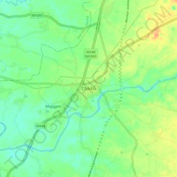
Name: Chikhli topographic map, elevation, terrain.

Location: Chikhli, Chikhli Taluka, Navsari, Gujarat, 396521, India (20.71814 73.01990 20.79814 73.09990)

Average elevation: 23 m

Minimum elevation: 8 m

Maximum elevation: 47 m

Gear up for your next adventure:

Lightweight Camping Tent - Portable shelter optimized for Canadian backcountry camping
🥾Approach Boots - Comfortable boots for hiking and climbing approaches
🥾Hiking Shoes - Durable and comfortable shoes for trail hiking
🥾Approach Shoes - Shoes designed for climbing approaches and rugged trails
🕯️Camping Lantern - Illuminates your entire campsite with high-efficiency LEDs

As an Amazon Associate, this site earns from qualifying purchases at no extra cost to you.