Geolocate

Thane topographic map

Click on the map to display elevation.

About this map

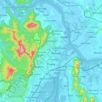
Name: Thane topographic map, elevation, terrain.

Location: Thane, Thane Taluka, Thane, Maharashtra, India (19.13165 72.91038 19.30019 73.07706)

Average elevation: 54 m

Minimum elevation: -4 m

Maximum elevation: 485 m

Other topographic maps

Click on a map to view its topography, its elevation and its terrain.

Panvel Creek

India > Maharashtra > Thane Taluka > Navi Mumbai

Average elevation: 5 m

Shill Gaon

India > Maharashtra > Thane Taluka > Thane

Average elevation: 36 m

Sector 15

India > Maharashtra > Thane Taluka > Navi Mumbai

Average elevation: 5 m

Reti Bandar

India > Maharashtra > Thane Taluka > Thane

Average elevation: 29 m

Uttan

India > Maharashtra > Thane Taluka > Mira-Bhayander

Average elevation: 11 m

Reti Bandar

India > Maharashtra > Thane Taluka > Thane

Average elevation: 29 m

Gear up for your next adventure:

🏕️Camping Hammock - Integrated protection for sleeping between trees
💧Filtered Water Bottle - Safe drinking water on the go
🧥Softshell Jacket - Windproof and breathable jacket for hiking
🧦Hiking Socks - Moisture-wicking and comfortable socks for long hikes
🧴Outdoor Sunscreen - High SPF protection for high-altitude UV exposure

As an Amazon Associate, this site earns from qualifying purchases at no extra cost to you.