
Rajasthan topographic map
Interactive map
Click on the map to display elevation.
About this map
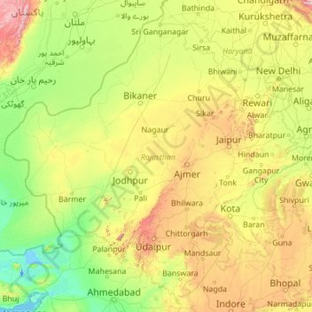
Name: Rajasthan topographic map, elevation, terrain.
Location: Rajasthan, India (23.05866 69.48444 30.19825 78.27201)
Average elevation: 254 m
Minimum elevation: -5 m
Maximum elevation: 2,299 m
The Aravalli Range runs across the state from the southwest peak Guru Shikhar (Mount Abu), which is 1,722 metres (5,650 ft) in height, to Khetri in the northeast. This range divides the state into 60% in the northwest of the range and 40% in the southeast. The northwest tract is sandy and unproductive with little water but improves gradually from desert land in the far west and northwest to comparatively fertile and habitable land towards the east. The south-eastern area, higher in elevation (100 to 350 m above sea level) and more fertile, has a very diversified topography. In the south lies the hilly tract of Mewar. In the southeast, a large area within the districts of Kota and Bundi forms a tableland. To the northeast of these districts is a rugged region (badlands) following the line of the Chambal River. Farther north the country levels out; the flat plains of the northeastern Bharatpur district are part of an alluvial basin. Merta City lies in the geographical center of Rajasthan.
Other topographic maps
Click on a map to view its topography, its elevation and its terrain.
Nava Raipur
India > Chhattisgarh > Arang Tahsil
Nava Raipur, Arang Tahsil, Raipur District, Chhattisgarh, India
Average elevation: 305 m
Shahapur Taluka
Shahapur Taluka, Thane District, Maharashtra, India
Average elevation: 224 m
Rajkot
India > Gujarat > Rajkot Taluka
Rajkot, Rajkot Taluka, Rajkot District, Gujarat, 360001, India
Average elevation: 141 m
Navi Mumbai
India > Maharashtra > Navi Mumbai
Navi Mumbai, Thane, Maharashtra, 400706, India
Average elevation: 30 m
Visakhapatnam
India > Andhra Pradesh > Visakhapatnam (Urban)
Visakhapatnam, Visakhapatnam (Urban), Visakhapatnam, Andhra Pradesh, 530001, India
Average elevation: 41 m
Saidabad
India > Rajasthan > Tonk Tehsil > Tonk
Saidabad, Tonk, Tonk Tehsil, Tonk District, Rajasthan, 304001, India
Average elevation: 273 m
Bewar
India > Uttar Pradesh > Bhogaon
Bewar, Bhogaon, Mainpuri District, Uttar Pradesh, 206300, India
Average elevation: 151 m
Lucknow
India > Uttar Pradesh > Lucknow
Lucknow, Lucknow District, Uttar Pradesh, 226027, India
Average elevation: 120 m
Tirupati
India > Andhra Pradesh > Tirupati (Urban)
Tirupati, Tirupati (Urban), Tirupati, Andhra Pradesh, 517500, India
Average elevation: 319 m
Kanchipuram
India > Tamil Nadu > Kanchipuram
Kanchipuram, Kancheepuram, Kanchipuram District, Tamil Nadu, 631501, India
Average elevation: 82 m
Vadodara Rural Taluka
Vadodara Rural Taluka, Vadodara District, Gujarat, India
Average elevation: 35 m
Deoli
India > Rajasthan > Deoli Tehsil
Deoli, Deoli Tehsil, Tonk District, Rajasthan, 323802, India
Average elevation: 332 m
Baba Bakala Tahsil
Baba Bakala Tahsil, Amritsar District, Punjab, India
Average elevation: 239 m
Tiruchirappalli
India > Tamil Nadu > Tiruchirappalli
Tiruchirappalli, Tiruchchirappalli district, Tamil Nadu, 620001, India
Average elevation: 83 m
Ponneri
India > Tamil Nadu > Ponneri
Ponneri, Thiruvallur District, Tamil Nadu, 601204, India
Average elevation: 10 m
Seelam Pur Tehsil
Seelam Pur Tehsil, North East Delhi District, Delhi, India
Average elevation: 208 m
Gandhinagar
India > Gujarat > Gandhinagar Taluka
Gandhinagar, Gandhinagar Taluka, Gandhinagar District, Gujarat, India
Average elevation: 75 m
Zemu Glacier
India > Sikkim > Chungthang
Zemu Glacier, Chungthang, Mangan District, Sikkim, India
Average elevation: 5,510 m
Chikhli
India > Gujarat > Chikhli Taluka
Chikhli, Chikhli Taluka, Navsari District, Gujarat, 396521, India
Average elevation: 23 m
Kaniyambādi
India > Tamil Nadu > Vellore
Kaniyambādi, Vellore, Vellore District, Tamil Nadu, 632102, India
Average elevation: 253 m
Rajpura
India > Rajasthan > Shahpura Tehsil
Rajpura, Shahpura Tehsil, Jaipur(Rural) District, Rajasthan, 303103, India
Average elevation: 451 m
Dudhsagar Falls
India > Goa > Dharbandora
Dudhsagar Falls, Dharbandora, South Goa District, Goa, India
Average elevation: 418 m
Sahaspur
India > Uttar Pradesh > Dhampur
Sahaspur, Dhampur, Bijnor District, Uttar Pradesh, 246745, India
Average elevation: 217 m
Lake Vasuki Tal
India > Uttarakhand > Ukhimath > Kedarnath
Lake Vasuki Tal, Kedarnath, Ukhimath, Rudraprayag District, Uttarakhand, India
Average elevation: 4,303 m
Ognaj
India > Gujarat > Ghatlodiya Taluka
Ognaj, Ghatlodiya Taluka, Ahmedabad District, Gujarat, 380060, India
Average elevation: 57 m
Ghatlodiya Taluka
Ghatlodiya Taluka, Ahmedabad District, Gujarat, India
Average elevation: 53 m
Collem
India > Goa > Dharbandora
Collem, Dharbandora, South Goa District, Goa, India
Average elevation: 90 m
Pratapsinghpura
India > Rajasthan > Neemrana Tehsil
Pratapsinghpura, Neemrana Tehsil, Kotputli-Behror District, Rajasthan, 301706, India
Average elevation: 309 m
Yaja
India > Arunachal Pradesh > Taksing Circle
Yaja, Taksing Circle, Upper Subansiri District, Arunachal Pradesh, India
Average elevation: 2,759 m
Burhanpur
Burhanpur, Azamgarh District, Uttar Pradesh, India
Average elevation: 82 m
Puducherry
India > Puducherry > Puducherry Taluk
Puducherry, Puducherry Taluk, Puducherry District, Puducherry, 605001, India
Average elevation: 10 m
Nesari
India > Maharashtra > Gadhinglaj
Nesari, Gadhinglaj, Kolhapur, Maharashtra, 416504, India
Average elevation: 730 m
Mhasale
India > Maharashtra > Amalner
Mhasale, Amalner, Jalgaon, Maharashtra, 425105, India
Average elevation: 196 m
Kanchanpur
Kanchanpur, Dasda, North Tripura District, Tripura, 799270, India
Average elevation: 66 m
Kanchanpura
India > Madhya Pradesh > Batiyagarh Tahsil
Kanchanpura, Batiyagarh Tahsil, Damoh District, Madhya Pradesh, India
Average elevation: 354 m
Kintada Kotapadu
India > Andhra Pradesh > K.Kotapadu
Kintada Kotapadu, K.Kotapadu, Anakapalli, Andhra Pradesh, 531034, India
Average elevation: 82 m
Tikamsingh ki Dhani
India > Rajasthan > Dechoo Tehsil
Tikamsingh ki Dhani, Dechoo Tehsil, Phalodi District, Rajasthan, India
Average elevation: 285 m
Biaora
India > Madhya Pradesh > Biaora Tahsil > Habirpura
Biaora, Habirpura, Biaora Tahsil, Rajgarh District, Madhya Pradesh, 465674, India
Average elevation: 429 m
Ambala
India > Haryana > Ambala Cantt
Ambala, Ambala Cantt, Ambala District, Haryana, 134002, India
Average elevation: 275 m
Umbraj
India > Maharashtra > Karad
Umbraj, Karad, Satara, Maharashtra, 415109, India
Average elevation: 594 m
Laccadive Islands
India > Lakshadweep > Agatti > Agatti
Laccadive Islands, Agatti, Lakshadweep District, Lakshadweep, 262240, India
Average elevation: 0 m