
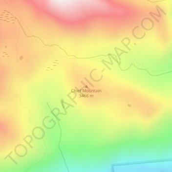
Chief Mountain topographic map
Interactive map
Click on the map to display elevation.
About this map
Name: Chief Mountain topographic map, elevation, terrain.
Location: Chief Mountain, Summit County, Colorado, United States (39.59049 -106.15591 39.59059 -106.15581)
Average elevation: 3,367 m
Minimum elevation: 2,948 m
Maximum elevation: 3,733 m
Other topographic maps
Click on a map to view its topography, its elevation and its terrain.
Cripple Creek
United States > Colorado > Teller County
For many years, Cripple Creek's high valley, at an elevation of 9,494 feet (2,894 m), was considered no more important than a cattle pasture. Many prospectors avoided the area after the Mount Pisgah hoax, a mini gold rush caused by salting (adding gold to worthless rock).
Average elevation: 2,946 m
Meeker
United States > Colorado > Rio Blanco County
According to the United States Census Bureau, the town has a total area of 2.9 square miles (7.5 km2), all of it land. The town is situated on the White River at an elevation of 6,250 feet above sea level.
Average elevation: 2,016 m
Greeley
United States > Colorado > Weld County
Greeley experiences a semi-arid climate (Köppen BSk). High temperatures are generally around 90–95 °F (32 °C) in the summer and 40-45 °F (4 °C) in the winter, although significant variation occurs. The hottest days generally occur around the third week of July and the coldest in January. Nighttime lows…
Average elevation: 1,448 m
Parker
United States > Colorado > Douglas County
Parker is located in northeastern Douglas County. Its northernmost border follows the Arapahoe County line, and the city of Aurora touches the town's northeast border. The center of Parker is 23 miles (37 km) southeast of downtown Denver. Castle Rock, the Douglas County seat, is 15 miles (24 km) to the…
Average elevation: 1,845 m
Aspen
United States > Colorado > Pitkin County
Aspen is the Home Rule City that is the county seat and the most populous municipality of Pitkin County, Colorado, United States. The city population was 7,004 at the 2020 United States Census. Aspen is in a remote area of the Rocky Mountains' Sawatch Range and Elk Mountains, along the Roaring Fork River at an…
Average elevation: 2,568 m
Crested Butte
United States > Colorado > Gunnison County
At the 2020 United States Census, the town had a total area of 535 acres (2.166 km2), all of it land. Crested Butte lies at an elevation of 8,885 feet (2,708 m) above sea level.
Average elevation: 2,798 m
Garden of the Gods Park
United States > Colorado > El Paso County > Colorado Springs
Average elevation: 1,982 m
Boulder County
Rocky Mountain National Park is in Boulder County, Larimer County, and Grand County. Longs Peak, the park's highest summit at 4,345 meters (14,255 feet) elevation, is located in Boulder County.
Average elevation: 2,308 m
Telluride
United States > Colorado > San Miguel County
Telluride has an elevation of 8,750 feet (2,670 m) in an isolated spot in Southwest Colorado. From the west, Colorado Route 145 is the most common way into Telluride; two other passes enter the town, Imogene Pass and Black Bear Pass.
Average elevation: 3,125 m
Montrose
United States > Colorado > Montrose County
Montrose features a semi-arid Continental climate zone. The town sits on high grasslands in the Uncompahgre Valley of Western Colorado. Snowfall occurs during the winter but is usually short-lived due to the high altitude and abundant sunshine.
Average elevation: 1,803 m
Monument
United States > Colorado > El Paso County
Monument experiences a hemiboreal continental climate (Köppen Dfb) with warm, relatively rainy summers and cold, snowy winters. As with many areas of Colorado, Monument experiences a lot of sunshine with an average of 250 sunny days per year. The semi-arid climate keeps the dew point very low in Monument…
Average elevation: 2,160 m
Lake County
Lake County is a county located in the U.S. state of Colorado. As of the 2020 census, the population was 7,436. The county seat and the only municipality in the county is Leadville. The highest natural point in Colorado and the entire Rocky Mountains is the summit of Mount Elbert in Lake County at 14,440 feet…
Average elevation: 3,398 m
Winter Park
United States > Colorado > Grand County
Its elevation ranges from approximately 8,700 to 12,060 feet (2,650 to 3,680 m) above sea level, and is considered sub-alpine country. It is snow-covered for about six months a year. Although the town center is at about 9,000 feet (2,700 m) above sea level, Winter Park, using administrative boundaries as a…
Average elevation: 3,068 m
Windsor
United States > Colorado > Weld County
Some days in the winter and spring can be warm and extremely dry, with Chinook winds often raising temperatures to near 70 °F (21 °C) in January and February, and sometimes to near 90 °F (32 °C) in April. Windsor's elevation and low year-round humidity means that nighttime low temperatures are practically…
Average elevation: 1,485 m
Estes Park
United States > Colorado > Larimer County
Estes Park sits at an elevation of 7,522 feet (2,293 m) on the front range of the Rocky Mountains at the eastern entrance of the Rocky Mountain National Park. Its north, south and east extremities border the Roosevelt National Forest. Lumpy Ridge lies immediately north of Estes Park.
Average elevation: 2,430 m
Sleeping Giant
United States > Colorado > El Paso County > Colorado Springs
Average elevation: 1,971 m
Estes Park
United States > Colorado > Larimer County
Estes Park sits at an elevation of 7,522 feet (2,293 m) on the front range of the Rocky Mountains at the eastern entrance of the Rocky Mountain National Park. Its location is 40°22′22″N 105°31′09″W / 40.372856°N 105.519136°W / 40.372856; -105.519136. Its north, south and east extremities…
Average elevation: 2,409 m
Fort Morgan
United States > Colorado > Morgan County
Fort Morgan is located at 40°15′12″N 103°47′57″W / 40.25333°N 103.79917°W / 40.25333; -103.79917 in Morgan County, Colorado at an elevation of 4,324 feet (1,318 m).
Average elevation: 1,315 m
Buena Vista
United States > Colorado > Chaffee County > Buena Vista
Buena Vista is located in central Colorado roughly midway between Salida and Leadville in the Upper Arkansas River Valley at an elevation of 7,965 feet (2,428 m). The area between Buena Vista and Salida is often referred to as the Denver & Rio Grande, South Park & Pacific, and Colorado Midland railroads. Many…
Average elevation: 2,457 m
White River National Forest
There are ten peaks with an elevation higher than 14,000 ft (4,267m), colloquially known as 14ers in the forest.
Average elevation: 2,835 m
Rio Grande, Pagosa, and Northern Railroad
United States > Colorado > Archuleta County > Nutria
Average elevation: 2,224 m
Fairplay
United States > Colorado > Park County > Fairplay
The historic Town of Fairplay is the Statutory Town that is the county seat and the most populous municipality of Park County, Colorado, United States. The town population was 724 at the 2020 United States Census. Fairplay is located in South Park at an elevation of 9,953 feet (3,034 m). The town is the…
Average elevation: 3,040 m
Broomfield
The elevation of Broomfield is 5,348 feet (1,630 m). At the 2020 United States Census, Broomfield had a total area of 21,471 acres (86.890 km2), including 371 acres (1.503 km2) of water. It is the smallest county by area in Colorado, and the 5th smallest in the United States.
Average elevation: 1,609 m
Crested Butte
United States > Colorado > Gunnison County
Crested Butte is located in north-central Gunnison County on the west side of the valley of the Slate River, along Coal Creek. Colorado State Highway 135 runs south from Crested Butte 27 miles (43 km) to Gunnison, the county seat. According to the United States Census Bureau, the town of Crested Butte has a…
Average elevation: 2,798 m
Nederland
United States > Colorado > Boulder County
In 1873 the Caribou Mine, at an elevation of roughly 10,000 feet (3,000 m) and 6 miles (10 km) northwest of the town, was sold to the Mining Company Nederland from the Netherlands. The high elevation meant fierce winds and deep winter snow, so the new owners of the mine decided that it was beneficial to bring…
Average elevation: 2,578 m
Woodland Park
United States > Colorado > Teller County
The area is characterized by the abundance of large granite rocks and alpine meadows, as well as its consistently high elevation ranging between 8,200 and 10,000 feet above sea level. The climate is considered arid which causes the surrounding forests to become very dry, posing a significant fire threat in…
Average elevation: 2,652 m
Castle Rock
United States > Colorado > Douglas County
Castle Rock is located at 39°22′20″N 104°51′22″W / 39.37222°N 104.85611°W / 39.37222; -104.85611 (39.372212, −104.856090) at an elevation of 6,224 feet (1,897 m). Castle Rock is in central Colorado at the junction of Interstate 25 and State Highway 86, 28 mi (45 km) south of downtown…
Average elevation: 1,952 m
Fort Garland
United States > Colorado > Costilla County
Fort Garland is located at an elevation of 7,936 ft (2,419 m) in northern Costilla County. Fort Garland is at the crossroads of U.S. Route 160 and Colorado State Highway 159, which leads south towards Taos and Santa Fe, New Mexico. The town of Blanca is 4 miles (6.4 km) west on U.S. Route 160. Walsenburg is 47…
Average elevation: 2,427 m