
Pavilion topographic map
Click on the map to display elevation.
Pavilion
The early anglicized version of the village name was Skwailuk, meaning hoar-frost, perhaps indicating the shaded ground remaining frozen during the long winters at this elevation. The Ts'kw'aylaxw First Nation (a.k.a. the Tsk'waylacw First Nation or Tsk'weylecw First Nation), residing on the Pavilion 1 Indian Reserve comprise most of the area population. The Pavilion dialect is a mix of St'at'imcets and Secwepemc'tsn and many of the place names in the surrounding country are Secwepemc'tsn.
About this map
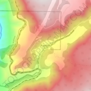
Name: Pavilion topographic map, elevation, terrain.
Location: Pavilion, British Columbia, Canada (50.86295 -121.84815 50.90295 -121.80815)
Average elevation: 855 m
Minimum elevation: 240 m
Maximum elevation: 1,241 m
British Columbia trails, hiking, mountain biking, running and outdoor activities
Other topographic maps
Click on a map to view its topography, its elevation and its terrain.
Vancouver
Canada > British Columbia > Metro Vancouver Regional District
Vancouver, British Columbia, is situated on the Burrard Peninsula, bordered by Burrard Inlet to the north and the Fraser River to the south. The city's topography is a blend of flat and hilly terrains, with elevations ranging from sea level to approximately 152 meters (500 feet) above sea level. The North…
Average elevation: 34 m
Victoria
Canada > British Columbia > Capital Regional District
Victoria, British Columbia, is situated on the southern tip of Vancouver Island, Canada, and boasts a diverse and varied topography. The city is characterized by rolling hills, rugged coastal cliffs, and lush valleys, providing a striking contrast between mountainous terrain and flatland areas. To the north…
Average elevation: 17 m
Prince George
Canada > British Columbia > Regional District of Fraser-Fort George
The area has a humid continental climate (Köppen climate classification Dfb, Trewartha Dclo), but is close to (and once had) a subarctic climate (Dfc) as May and September averages are both close to the 10 °C (50 °F) threshold. Winters are milder than the latitude and elevation might suggest: the January…
Average elevation: 685 m
Kelowna
Canada > British Columbia > Regional District of Central Okanagan
Kelowna is classified as a humid continental climate or an inland oceanic climate per the Köppen climate classification system due to its coldest month having an average temperature slightly above −3.0 °C (26.6 °F) and below 0 °C (32 °F), with dry, hot, sunny summers and cool, cloudy winters, and four…
Average elevation: 704 m
Mission
Canada > British Columbia > Fraser Valley Regional District
The western part of the district, the Stave Valley, is largely rural and forested but its watercourse is home to what was the largest hydroelectric project in British Columbia until the Bridge River Power Project opened in 1961. It was built by the British Columbia Electric Railway (BCER) to provide power to…
Average elevation: 345 m
Vancouver Island
The rain shadow effect of the island's mountains, as well as the mountains of Washington's Olympic Peninsula, creates wide variation in precipitation. The west coast is considerably wetter than the east coast. Average annual precipitation ranges from 6,650 mm (262 in) at Hucuktlis Lake on the west coast…
Average elevation: 411 m
Burnaby
Canada > British Columbia > Metro Vancouver Regional District
Burnaby occupies 98.6 square kilometres (38.1 sq mi) and is located at the geographic centre of the Metro Vancouver Regional District. The regional district's government is located in Burnaby's Metrotown area. Situated between the city of Vancouver on the west and Port Moody, Coquitlam, and New Westminster on…
Average elevation: 59 m
Hornby Island
Canada > British Columbia > Comox Valley Regional District > Area A (Baynes Sound)
Average elevation: 27 m
Coquitlam
Canada > British Columbia > Metro Vancouver Regional District
Like much of Metro Vancouver, Coquitlam has an oceanic climate (Köppen climate type Cfb), experiencing mild temperatures and high precipitation; warm, dry summers and cool, wet winters. However, compared to most other cities in the area, precipitation is especially heavy in Coquitlam due to its proximity to…
Average elevation: 190 m
Gabriola Island
Canada > British Columbia > Regional District of Nanaimo > Area B (DeCourcy/Gabriola/Mudge)
Gabriola is about 14 kilometres (9 mi) long by 4.2 kilometres (2.6 mi) wide on average with a land area of 57.6 square kilometres (22.2 sq mi). The topography varies from flat sandy beaches at sea level to forested hills rising to 160 metres (525 ft) on Stoney Ridge in the centre of the island.
Average elevation: 26 m
Osoyoos
Canada > British Columbia > Regional District of Okanagan-Similkameen
Average elevation: 326 m
Quadra Island
Canada > British Columbia > Strathcona Regional District > Area B (Discovery Islands/Mainland Inlets)
Average elevation: 128 m
Lake Country
Canada > British Columbia > Regional District of Central Okanagan
Average elevation: 650 m
Malcolm Island
Canada > British Columbia > Regional District of Mount Waddington > Area A (Seymour Inlet/Knight Inlet)
Average elevation: 21 m
Kitsilano
Canada > British Columbia > Metro Vancouver Regional District > Vancouver
Average elevation: 24 m
West Kelowna
Canada > British Columbia > Regional District of Central Okanagan
Average elevation: 649 m
Township of Langley
Canada > British Columbia > Metro Vancouver Regional District
Average elevation: 47 m
University Endowment Lands
Canada > British Columbia > Metro Vancouver Regional District
Snowfalls are also more common than many parts of the City of Vancouver because of the area's higher altitude and the lack of an urban heat island due to less terrestrial development.
Average elevation: 58 m
Stanley Park
Canada > British Columbia > Metro Vancouver Regional District > Vancouver
Average elevation: 14 m
Sheridan Lake
Canada > British Columbia > Cariboo Regional District > Area L (Lone Butte/Interlakes)
Average elevation: 1,127 m
Crescent Beach
Canada > British Columbia > Metro Vancouver Regional District > Surrey
Average elevation: 22 m
Shuswap Lake
Canada > British Columbia > Columbia-Shuswap Regional District > Area F (Scotch Creek/Seymour Arm)
Average elevation: 1,064 m
Vargas Island
Canada > British Columbia > Alberni-Clayoquot Regional District > Area C (Long Beach)
Average elevation: 11 m
Little Heffley Lake
Canada > British Columbia > Thompson-Nicola Regional District > Area P (Rivers and the Peaks)
Average elevation: 1,035 m
Valemount
Canada > British Columbia > Regional District of Fraser-Fort George
Average elevation: 795 m
North Pender Island
Canada > British Columbia > Capital Regional District > Southern Gulf Islands Electoral Area
Average elevation: 23 m
Kootenay Lake
Canada > British Columbia > Regional District of Central Kootenay
Average elevation: 1,609 m
Quesnel Lake
Canada > British Columbia > Cariboo Regional District > Area F (Horsefly/Likely/150 Mile House)
Average elevation: 1,311 m
Prince Rupert
Canada > British Columbia > North Coast Regional District
Prince Rupert Airport (YPR/CYPR) is on Digby Island. Its position is 54°17′10″N 130°26′41″W / 54.28611°N 130.44472°W / 54.28611; -130.44472, and its elevation is 35 m (116 ft) above sea level. The airport consists of one runway, one passenger terminal, and two aircraft stands. Access to…
Average elevation: 91 m
Woodlot 0007
Canada > British Columbia > Metro Vancouver Regional District > Maple Ridge
Average elevation: 322 m
Mayne Island
Canada > British Columbia > Capital Regional District > Southern Gulf Islands Electoral Area > Mayne
Average elevation: 26 m
Grand Forks
Canada > British Columbia > Regional District of Kootenay Boundary
Average elevation: 586 m
Okanagan Lake
Canada > British Columbia > Regional District of Central Okanagan > Kelowna
Average elevation: 1,194 m
Kamloops Lake
Canada > British Columbia > Thompson-Nicola Regional District > Area J (Copper Desert Country)
Average elevation: 975 m
Big Peters Lake
Canada > British Columbia > Regional District of North Okanagan > Area E (Cherryville/East Creighton)
Average elevation: 1,850 m
East Sooke
Canada > British Columbia > Capital Regional District > Juan de Fuca Electoral Area
Average elevation: 55 m
Linley Valley
Canada > British Columbia > Regional District of Nanaimo > Nanaimo
Average elevation: 76 m
Vancouver Island
The rain shadow effect of the island's mountains, as well as the mountains of Washington's Olympic Peninsula, creates wide variation in precipitation. The west coast is considerably wetter than the east coast. Average annual precipitation ranges from 6,650 mm (262 in) at Hucuktlis Lake on the west coast…
Average elevation: 411 m
Green Lake
Canada > British Columbia > Thompson-Nicola Regional District > Area E (Bonaparte Plateau)
Average elevation: 1,111 m
Cloverdale
Canada > British Columbia > Metro Vancouver Regional District > Surrey
Average elevation: 24 m
Stave Lake
Canada > British Columbia > Area F (McConnell Creek/Hatzic Prairie)
Average elevation: 576 m
Tsawwassen
Canada > British Columbia > Metro Vancouver Regional District > Delta
Average elevation: 12 m
Langford Lake
Canada > British Columbia > Capital Regional District > Langford
Average elevation: 105 m
Hernando Island
Canada > British Columbia > qathet Regional District > Area A (Malaspina/Toba)
Average elevation: 23 m
Area C (Blind Bay/Sorrento)
Canada > British Columbia > Columbia-Shuswap Regional District
Average elevation: 795 m
Radium Hot Springs
Canada > British Columbia > Regional District of East Kootenay
Average elevation: 912 m
Chetwynd
Canada > British Columbia > Peace River Regional District
Carved out of an ancient floodplain, the small terrace upon which Chetwynd is situated lies in the northern foothills of the Rocky Mountains. Once used as a grazing spot by nomadic Aboriginals, the terrace was farmed by settlers until it was developed into a town. Two types of soil—namely, the Widmark and…
Average elevation: 910 m
Princeton
Canada > British Columbia > Regional District of Okanagan-Similkameen
Average elevation: 710 m
Pitt Lake
Canada > British Columbia > Metro Vancouver Regional District > Electoral Area A
Average elevation: 659 m
Saltspring Island
Canada > British Columbia > Capital Regional District > Salt Spring Island Electoral Area
Average elevation: 72 m