
Princeton topographic map
Click on the map to display elevation.
About this map
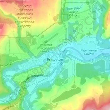
Name: Princeton topographic map, elevation, terrain.
Average elevation: 710 m
Minimum elevation: 620 m
Maximum elevation: 913 m
Other topographic maps
Click on a map to view its topography, its elevation and its terrain.
Manning Park
Canada > British Columbia > Regional District of Okanagan-Similkameen > Area H (Manning Park/Tulameen/Siwash)
Average elevation: 1,420 m
Tulameen
Canada > British Columbia > Regional District of Okanagan-Similkameen > Area H (Manning Park/Tulameen/Siwash)
Average elevation: 923 m
Chute Lake
Canada > British Columbia > Regional District of Okanagan-Similkameen > Area E (Naramata/Greyback)
Average elevation: 1,273 m
Agur Lake
Canada > British Columbia > Regional District of Okanagan-Similkameen > Area F (Trout Creek Valley)
Average elevation: 1,178 m
Faulder
Canada > British Columbia > Regional District of Okanagan-Similkameen > Area F (Trout Creek Valley)
Average elevation: 850 m
Bankeir
Canada > British Columbia > Regional District of Okanagan-Similkameen > Area H (Manning Park/Tulameen/Siwash)
Average elevation: 1,226 m
Garnet Valley Dam
Canada > British Columbia > Regional District of Okanagan-Similkameen > Summerland
Average elevation: 799 m
Naramata
Canada > British Columbia > Regional District of Okanagan-Similkameen > Area E (Naramata/Greyback)
Average elevation: 414 m
Chapman Lake
Canada > British Columbia > Regional District of Okanagan-Similkameen > Area H (Manning Park/Tulameen/Siwash)
Average elevation: 1,669 m
Glacier Lake
Canada > British Columbia > Regional District of Okanagan-Similkameen > Area G (Upper Similkameen/Hedley)
Average elevation: 2,291 m
Cascade Mountains
Canada > British Columbia > Regional District of Okanagan-Similkameen > Area B (Cawston/Lower Similkameen)
Average elevation: 1,207 m
Allison Lake
Canada > British Columbia > Regional District of Okanagan-Similkameen > Area H (Manning Park/Tulameen/Siwash)
Average elevation: 1,141 m
Okanagan Falls
Canada > British Columbia > Regional District of Okanagan-Similkameen > Area D (Skaha East/Okanagan Falls)
Average elevation: 478 m
Cawston
Canada > British Columbia > Regional District of Okanagan-Similkameen > Area B (Cawston/Lower Similkameen)
Average elevation: 410 m
Penticton
Canada > British Columbia > Regional District of Okanagan-Similkameen > Penticton
Penticton is located at the geographical coordinates of 49°29′28″N 119°35′19″W / 49.49111°N 119.58861°W / 49.49111; -119.58861 (Penticton) and covers an area of 42.10 km2 (16.25 sq mi), with a maximum north–south distance of 7 km (4.3 mi) wide between the Okanagan Lake to the north…
Average elevation: 1,044 m
Okanagan Highland
Canada > British Columbia > Regional District of Okanagan-Similkameen > Area E (Naramata/Greyback)
Average elevation: 816 m
Greyback Lake
Canada > British Columbia > Regional District of Okanagan-Similkameen > Area E (Naramata/Greyback)
Average elevation: 1,627 m
Marron Valley
Canada > British Columbia > Regional District of Okanagan-Similkameen > Area I (Skaha West/Kaleden/Apex)
Average elevation: 772 m
Rampart Lake
Canada > British Columbia > Regional District of Okanagan-Similkameen > Area H (Manning Park/Tulameen/Siwash)
Average elevation: 1,333 m
Allenby
Canada > British Columbia > Regional District of Okanagan-Similkameen > Area H (Manning Park/Tulameen/Siwash)
Average elevation: 850 m
Olivine Mountain
Canada > British Columbia > Regional District of Okanagan-Similkameen > Area H (Manning Park/Tulameen/Siwash)
Average elevation: 1,537 m
Blakeburn
Canada > British Columbia > Regional District of Okanagan-Similkameen > Area H (Manning Park/Tulameen/Siwash)
Average elevation: 1,188 m
Hedley
Canada > British Columbia > Regional District of Okanagan-Similkameen > Area G (Upper Similkameen/Hedley)
Average elevation: 822 m
Jellicoe
Canada > British Columbia > Regional District of Okanagan-Similkameen > Area H (Manning Park/Tulameen/Siwash)
Average elevation: 1,206 m
Chain Lake
Canada > British Columbia > Regional District of Okanagan-Similkameen > Area H (Manning Park/Tulameen/Siwash)
Average elevation: 1,165 m
Frosty Mountain
Canada > British Columbia > Regional District of Okanagan-Similkameen > Area H (Manning Park/Tulameen/Siwash)
Average elevation: 2,010 m
Isintok Mountain
Canada > British Columbia > Regional District of Okanagan-Similkameen > Area F (Trout Creek Valley)
Average elevation: 1,739 m
Coalmont
Canada > British Columbia > Regional District of Okanagan-Similkameen > Area H (Manning Park/Tulameen/Siwash)
Average elevation: 966 m
Manning Park
Canada > British Columbia > Regional District of Okanagan-Similkameen > Area H (Manning Park/Tulameen/Siwash)
Average elevation: 1,420 m
Hedley
Canada > British Columbia > Regional District of Okanagan-Similkameen > Area G (Upper Similkameen/Hedley)
Average elevation: 822 m
Cascade Mountains
Canada > British Columbia > Regional District of Okanagan-Similkameen > Area B (Cawston/Lower Similkameen)
Average elevation: 1,207 m
Okanagan Falls
Canada > British Columbia > Regional District of Okanagan-Similkameen > Area D (Skaha East/Okanagan Falls)
Average elevation: 478 m
Cascade Mountains
Canada > British Columbia > Regional District of Okanagan-Similkameen > Area G (Upper Similkameen/Hedley)
Average elevation: 1,979 m
Tulameen
Canada > British Columbia > Regional District of Okanagan-Similkameen > Area H (Manning Park/Tulameen/Siwash)
Average elevation: 923 m