Geolocate

Stave Lake topographic map

Click on the map to display elevation.

About this map

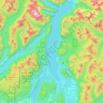
Name: Stave Lake topographic map, elevation, terrain.

Location: Stave Lake, Area F (McConnell Creek/Hatzic Prairie), British Columbia, Canada (49.22937 -122.36514 49.45823 -122.21853)

Average elevation: 576 m

Minimum elevation: 58 m

Maximum elevation: 2,054 m

British Columbia trails, hiking, mountain biking, running and outdoor activities

Other topographic maps

Click on a map to view its topography, its elevation and its terrain.

Gear up for your next adventure:

🥾Light Trekking Boots - Supportive boots for multi-day treks
🥾Approach Shoes - Shoes designed for climbing approaches and rugged trails
🎒Hiking Daypack - Lightweight and durable backpacks for day trips and excursions
🛏️Sleeping Bag - Warm and compact sleeping bags for outdoor camping
👟Sport Hiking Sandals - Breathable footwear for water crossings and camp rest

As an Amazon Associate, this site earns from qualifying purchases at no extra cost to you.