
Linley Valley topographic map
Click on the map to display elevation.
About this map
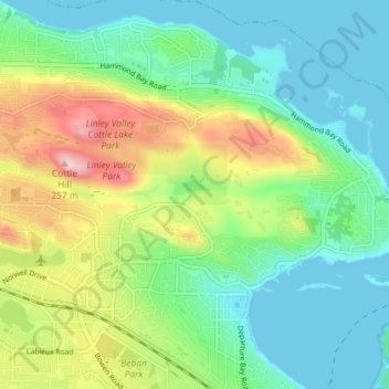
Name: Linley Valley topographic map, elevation, terrain.
Average elevation: 76 m
Minimum elevation: -1 m
Maximum elevation: 244 m
Regional District of Nanaimo trails, hiking, mountain biking, running and outdoor activities
Other topographic maps
Click on a map to view its topography, its elevation and its terrain.
Colliery Dam Park
Canada > British Columbia > Regional District of Nanaimo > Nanaimo
Average elevation: 99 m
Cathers Lake
Canada > British Columbia > Regional District of Nanaimo > Nanaimo
Average elevation: 119 m
East Wellington Park
Canada > British Columbia > Regional District of Nanaimo > Nanaimo
Average elevation: 99 m
Colinwood Park
Canada > British Columbia > Regional District of Nanaimo > Nanaimo
Average elevation: 104 m