Geolocate

Adventure Bay topographic map

Click on the map to display elevation.

About this map

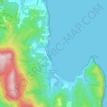
Name: Adventure Bay topographic map, elevation, terrain.

Location: Adventure Bay, Kingborough, Tasmania, 7150, Australia (-43.38756 147.30168 -43.30767 147.36499)

Average elevation: 110 m

Minimum elevation: -2 m

Maximum elevation: 563 m

Other topographic maps

Click on a map to view its topography, its elevation and its terrain.

Freycinet Peninsula

Australia > Tasmania

Average elevation: 303 m

Moonlight Hill

Australia > Tasmania > Tasman

Average elevation: 144 m

Bell Mount

Australia > Tasmania

Average elevation: 541 m

Gear up for your next adventure:

Backpacking Tent - Lightweight tent for long-distance hiking trips
🔭Compact Monocular - One-handed bird watching and trail spotting
👟Sport Hiking Sandals - Breathable footwear for water crossings and camp rest
🥾Hiking Shoes - Durable and comfortable shoes for trail hiking
Camping Groundsheet - Protect your tent from moisture and dirt

As an Amazon Associate, this site earns from qualifying purchases at no extra cost to you.