
Shire of Hepburn topographic map
Interactive map
Click on the map to display elevation.
About this map
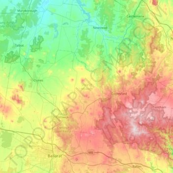
Name: Shire of Hepburn topographic map, elevation, terrain.
Location: Shire of Hepburn, Victoria, Australia (-37.48646 143.64806 -37.14760 144.41903)
Average elevation: 432 m
Minimum elevation: 186 m
Maximum elevation: 875 m
Other topographic maps
Click on a map to view its topography, its elevation and its terrain.
Horsham
Horsham's topography is flat, approximately 128 metres (420 ft) above sea level. The central business district (CBD) is laid out in a grid plan south of the train line and is characterised by wide streets and several roundabouts. Firebrace Street, running north–south through the middle of the CBD is one of…
Average elevation: 129 m
Kerang
Kerang is a rural town on the Loddon River in northern Victoria in Australia. It is the commercial centre to an irrigation district based on livestock, horticulture, lucerne and grain. It is located 279 kilometres (173 mi) north-west of Melbourne on the Murray Valley Highway a few kilometres north of its…
Average elevation: 78 m