Geolocate

Kedron topographic map

Click on the map to display elevation.

About this map

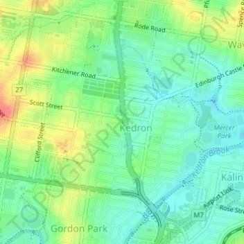
Name: Kedron topographic map, elevation, terrain.

Location: Kedron, Brisbane City, Queensland, 4031, Australia (-27.41623 153.01926 -27.39275 153.04223)

Average elevation: 28 m

Minimum elevation: 6 m

Maximum elevation: 65 m

Other topographic maps

Click on a map to view its topography, its elevation and its terrain.

Grange Heights

Australia > Queensland > Brisbane City

Average elevation: 34 m

Gear up for your next adventure:

🧰Survival Kit - Essential gear for emergencies in the wilderness
🧦Merino Wool Socks - Moisture-wicking comfort for long-distance hiking
🧥Insulated Jacket - Keep warm in cold outdoor conditions
💧Hydration Bladder - Hands-free hydration solution for long treks
🔭Compact Monocular - One-handed bird watching and trail spotting

As an Amazon Associate, this site earns from qualifying purchases at no extra cost to you.