Geolocate

Gretna topographic map

Click on the map to display elevation.

About this map

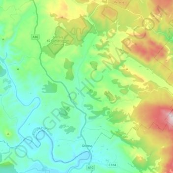
Name: Gretna topographic map, elevation, terrain.

Location: Gretna, Central Highlands, Tasmania, 7140, Australia (-42.69502 146.84744 -42.56639 147.03962)

Average elevation: 272 m

Minimum elevation: 23 m

Maximum elevation: 892 m

Other topographic maps

Click on a map to view its topography, its elevation and its terrain.

Freycinet Peninsula

Australia > Tasmania

Average elevation: 303 m

Moonlight Hill

Australia > Tasmania > Tasman

Average elevation: 144 m

Bell Mount

Australia > Tasmania

Average elevation: 541 m

Gear up for your next adventure:

🧦Hiking Socks - Moisture-wicking and comfortable socks for long hikes
🎒Hiking Backpack - Lightweight and ergonomic backpacks for day hikes or multi-day treks
💧Hydration Pack - Hands-free hydration system for long hikes
🧭GPS Tracker - Track your location in remote areas safely
🧥Waterproof Jacket - Lightweight rain jackets for hiking and outdoor activities

As an Amazon Associate, this site earns from qualifying purchases at no extra cost to you.