
Machakos County topographic map
Click on the map to display elevation.
Machakos County
The local climate is semi-arid with hilly terrain and an altitude of 1000 to 2100 metres above sea level.
About this map
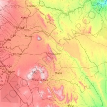
Name: Machakos County topographic map, elevation, terrain.
Location: Machakos County, Eastern, Kenya (-1.78016 36.87891 -0.77705 37.86750)
Average elevation: 1,347 m
Minimum elevation: 721 m
Maximum elevation: 2,138 m
Other topographic maps
Click on a map to view its topography, its elevation and its terrain.
Busia
Kenya > Busia County > Teso South
Busia, Kenya is located in Busia County, approximately 451 kilometres (280 mi), by road, northwest of Nairobi, Kenya's capital and largest city. This location is immediately east of Busia, Uganda. The coordinates of Busia, Kenya are: 00°27'48.0"N, 34°06'19.0"E (Latitude:0.463333; Longitude:34.105278). Busia,…
Average elevation: 1,201 m
Kisumu
The name Kisumu literally means a place of barter trade "sumo". The city has "Friendship" status with Cheltenham, United Kingdom and "sister city" status with Roanoke, Virginia and Boulder, Colorado, United States. Its elevation is 1,131 m (3,711 ft) above sea level. Kisumu is about 320 km (200 mi) northwest…
Average elevation: 1,155 m